
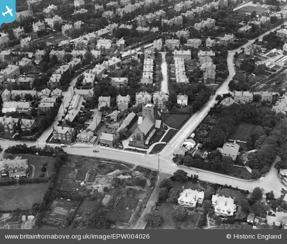
EPW004026 ENGLAND (1920). St Saviour's Church, Oxton, 1920
© Copyright OpenStreetMap contributors and licensed by the OpenStreetMap Foundation. 2025. Cartography is licensed as CC BY-SA.
Details
| Title | [EPW004026] St Saviour's Church, Oxton, 1920 |
| Reference | EPW004026 |
| Date | July-1920 |
| Link | |
| Place name | OXTON |
| Parish | |
| District | |
| Country | ENGLAND |
| Easting / Northing | 330145, 387796 |
| Longitude / Latitude | -3.0503109767427, 53.382123509439 |
| National Grid Reference | SJ301878 |
Pins

Tim |
Thursday 10th of March 2016 12:20:18 PM | |
|
Tim |
Thursday 10th of March 2016 12:19:38 PM | |
|
Tim |
Thursday 10th of March 2016 12:18:43 PM | |
|
Pete65 |
Saturday 26th of July 2014 04:17:44 PM | |
|
Pete65 |
Saturday 26th of July 2014 04:15:24 PM | |
All I can recall of this area in 1950's was a bomb site till the new Carnarvon Castle was built. |
Tim |
Thursday 10th of March 2016 12:29:58 PM |
|
hughes di |
Tuesday 21st of January 2014 06:43:19 PM | |
|
hughes di |
Tuesday 21st of January 2014 06:42:41 PM | |
|
hughes di |
Tuesday 21st of January 2014 06:42:02 PM | |
|
hughes di |
Tuesday 21st of January 2014 06:41:22 PM | |
|
hughes di |
Tuesday 21st of January 2014 06:40:47 PM | |
|
hughes di |
Tuesday 21st of January 2014 06:39:52 PM | |
|
Pete65 |
Monday 14th of October 2013 11:13:05 AM | |
Sorry Pete - this is Eldon House, 1 Village Road. Oxton Hall is off this image to the right |
Tim |
Thursday 10th of March 2016 12:11:44 PM |
|
Pete65 |
Monday 14th of October 2013 11:12:37 AM | |
Sorry again this 2 Bidston Road one time part of Eldon House property. Oxton Old hall is likewise off image |
Tim |
Thursday 10th of March 2016 12:14:10 PM |
|
eugene |
Sunday 21st of July 2013 11:59:13 PM | |
This has always been just Townfield Lane. Flatt Lane is down the hill |
Tim |
Thursday 10th of March 2016 12:16:38 PM |
|
eugene |
Sunday 21st of July 2013 11:58:26 PM |