
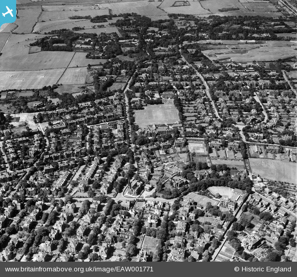
EAW001771 ENGLAND (1946). Housing around Birkenhead School on Shrewsbury Road and environs, Oxton, 1946
© Copyright OpenStreetMap contributors and licensed by the OpenStreetMap Foundation. 2026. Cartography is licensed as CC BY-SA.
Details
| Title | [EAW001771] Housing around Birkenhead School on Shrewsbury Road and environs, Oxton, 1946 |
| Reference | EAW001771 |
| Date | 11-July-1946 |
| Link | |
| Place name | OXTON |
| Parish | |
| District | |
| Country | ENGLAND |
| Easting / Northing | 330049, 388156 |
| Longitude / Latitude | -3.0518338785635, 53.385346527326 |
| National Grid Reference | SJ300882 |
Pins

Graham |
Thursday 3rd of August 2017 08:26:09 AM | |
|
Graham |
Thursday 3rd of August 2017 08:25:41 AM | |
|
Graham |
Thursday 3rd of August 2017 08:24:41 AM | |
|
Graham |
Friday 28th of July 2017 01:44:13 PM | |
|
Graham |
Tuesday 25th of July 2017 07:14:31 PM | |
|
Graham |
Tuesday 25th of July 2017 07:06:53 PM | |
|
Graham |
Tuesday 25th of July 2017 07:02:25 PM | |
|
Graham |
Tuesday 25th of July 2017 06:59:36 PM | |
|
Graham |
Tuesday 25th of July 2017 06:58:42 PM | |
|
Graham |
Tuesday 25th of July 2017 06:55:27 PM | |
|
Graham |
Tuesday 25th of July 2017 06:48:53 PM | |
|
Graham |
Tuesday 25th of July 2017 06:48:07 PM | |
|
Graham |
Tuesday 25th of July 2017 06:46:10 PM | |
|
Graham |
Tuesday 25th of July 2017 06:32:40 PM | |
|
Graham |
Tuesday 25th of July 2017 06:31:18 PM | |
|
Graham |
Tuesday 25th of July 2017 06:29:44 PM | |
|
Graham |
Tuesday 25th of July 2017 06:27:50 PM | |
|
Graham |
Tuesday 25th of July 2017 06:17:39 PM | |
|
Graham |
Tuesday 25th of July 2017 06:17:06 PM | |
|
Graham |
Tuesday 25th of July 2017 06:10:08 PM | |
|
Graham |
Tuesday 25th of July 2017 06:08:37 PM | |
|
Graham |
Tuesday 25th of July 2017 05:53:32 PM | |
|
Graham |
Tuesday 25th of July 2017 05:52:53 PM | |
|
Graham |
Tuesday 25th of July 2017 05:47:22 PM | |
|
Graham |
Tuesday 25th of July 2017 05:35:34 PM | |
|
Graham |
Tuesday 25th of July 2017 05:33:59 PM | |
|
Graham |
Tuesday 25th of July 2017 05:30:58 PM | |
|
Graham |
Tuesday 25th of July 2017 05:29:16 PM | |
|
Graham |
Tuesday 25th of July 2017 05:26:14 PM | |
|
Graham |
Tuesday 25th of July 2017 04:40:41 PM | |
|
CBB |
Saturday 3rd of June 2017 05:31:24 PM | |
|
Pete65 |
Sunday 23rd of February 2014 04:52:40 AM | |
|
Roger Reid |
Wednesday 19th of February 2014 03:35:03 AM | |
|
Roger Reid |
Tuesday 18th of February 2014 03:34:00 AM | |
|
Steve |
Friday 7th of February 2014 05:07:33 PM | |
|
Steve |
Friday 7th of February 2014 05:01:44 PM | |
|
Steve |
Friday 7th of February 2014 05:00:24 PM | |
|
Steve |
Friday 7th of February 2014 04:59:34 PM | |
|
Steve |
Friday 7th of February 2014 04:58:37 PM | |
|
vandyke |
Thursday 23rd of January 2014 04:24:12 PM | |
|
hughes di |
Tuesday 21st of January 2014 07:09:00 PM | |
|
hughes di |
Tuesday 21st of January 2014 07:07:55 PM | |
|
hughes di |
Tuesday 21st of January 2014 07:07:10 PM |