
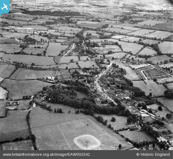
EAW001541 ENGLAND (1946). The town, Chipping Ongar, from the north, 1946
© Copyright OpenStreetMap contributors and licensed by the OpenStreetMap Foundation. 2025. Cartography is licensed as CC BY-SA.
Nearby Images (3)
EAW001541

EAW001542

EAW037034

Details
| Title | [EAW001541] The town, Chipping Ongar, from the north, 1946 |
| Reference | EAW001541 |
| Date | 5-July-1946 |
| Link | |
| Place name | CHIPPING ONGAR |
| Parish | ONGAR |
| District | |
| Country | ENGLAND |
| Easting / Northing | 555369, 203288 |
| Longitude / Latitude | 0.24885257562577, 51.706328232017 |
| National Grid Reference | TL554033 |
Pins

Ray Flack |
Thursday 18th of September 2014 05:47:26 PM | |
|
Ray Flack |
Thursday 18th of September 2014 05:40:35 PM | |
|
Ray Flack |
Thursday 18th of September 2014 05:31:33 PM | |
 |
Ray Flack |
Thursday 18th of September 2014 05:26:59 PM |
|
Ray Flack |
Thursday 18th of September 2014 04:52:20 PM | |
|
Ray Flack |
Thursday 18th of September 2014 04:50:25 PM | |
|
Ray Flack |
Thursday 18th of September 2014 04:33:49 PM | |
|
Ray Flack |
Thursday 18th of September 2014 04:32:05 PM | |
|
Ray Flack |
Thursday 18th of September 2014 04:31:07 PM | |
|
Ray Flack |
Thursday 18th of September 2014 04:28:19 PM | |
|
Ray Flack |
Thursday 18th of September 2014 04:27:39 PM | |
|
Ray Flack |
Thursday 18th of September 2014 04:19:08 PM | |
|
Ray Flack |
Thursday 18th of September 2014 04:18:24 PM | |
|
Ray Flack |
Thursday 18th of September 2014 04:09:03 PM | |
|
Ray Flack |
Thursday 18th of September 2014 04:08:06 PM | |
|
Ray Flack |
Thursday 18th of September 2014 04:02:17 PM | |
|
Ray Flack |
Thursday 18th of September 2014 03:57:40 PM | |
|
Ray Flack |
Thursday 18th of September 2014 03:56:46 PM | |
|
Ray Flack |
Thursday 18th of September 2014 03:52:18 PM | |
|
Ray Flack |
Thursday 18th of September 2014 03:50:38 PM | |
|
Ray Flack |
Thursday 18th of September 2014 03:50:22 PM | |
|
Ray Flack |
Thursday 18th of September 2014 03:48:44 PM | |
|
Ray Flack |
Thursday 18th of September 2014 03:46:38 PM | |
|
Ray Flack |
Thursday 18th of September 2014 03:45:28 PM | |
|
Ray Flack |
Thursday 18th of September 2014 03:39:26 PM | |
|
Ray Flack |
Thursday 18th of September 2014 03:36:29 PM | |
|
Ray Flack |
Thursday 18th of September 2014 03:35:30 PM | |
|
Ray Flack |
Thursday 18th of September 2014 03:34:54 PM | |
|
Ray Flack |
Thursday 18th of September 2014 03:33:59 PM |
