
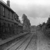
XAW051680 NORTHERN IRELAND (1953). Belfast Spec, Belfast, Belfast, Northern Ireland, 1953. Oblique aerial photograph taken facing North. This image was marked by Aerofilms Ltd for photo editing and has been produced from a damaged negative.

© Copyright OpenStreetMap contributors and licensed by the OpenStreetMap Foundation. 2026. Cartography is licensed as CC BY-SA.
Details
| Title | [XAW051680] Belfast Spec, Belfast, Belfast, Northern Ireland, 1953. Oblique aerial photograph taken facing North. This image was marked by Aerofilms Ltd for photo editing and has been produced from a damaged negative. |
| Reference | XAW051680 |
| Date | 26-August-1953 |
| Link | |
| Place name | BELFAST |
| Parish | NORTHERN IRELAND |
| District | |
| Country | NORTHERN IRELAND |
| Easting / Northing | 150005, 529547 |
| Longitude / Latitude | -5.871966, 54.59907 |
| National Grid Reference |
Pins

Smeeho7 |
Monday 13th of May 2024 01:47:00 PM | |
|
Keith1402 |
Wednesday 25th of May 2022 11:09:21 AM | |
|
Smartie |
Saturday 20th of February 2021 11:36:43 PM | |
|
TJ44 |
Thursday 3rd of October 2019 08:58:15 AM | |
|
Frank |
Tuesday 2nd of July 2019 06:00:34 PM | |
|
Frank |
Tuesday 2nd of July 2019 05:59:00 PM | |
|
Frank |
Tuesday 2nd of July 2019 05:58:19 PM | |
|
Frank |
Tuesday 2nd of July 2019 05:56:51 PM | |
|
Frank |
Sunday 30th of June 2019 04:01:40 PM | |
|
Mike |
Sunday 23rd of June 2019 03:37:29 AM | |
JGGB |
Wednesday 2nd of December 2015 01:50:14 AM | |
|
JGGB |
Wednesday 2nd of December 2015 01:49:38 AM | |
|
JGGB |
Wednesday 2nd of December 2015 01:48:19 AM | |
|
JGGB |
Wednesday 2nd of December 2015 01:47:21 AM |
User Comment Contributions
BCDR railway line from North Road bridge (left) to Neill's Hill Railway Station on right. Sandhill Gardens houses have just been built. Clara Park, Neill's Hill Park and Sandhill Park surround the wee housing development in centre right. Orangefield is full of allotments to left. Railway had closed but had not yet been lifted. |
JGGB |
Monday 13th of October 2014 02:06:13 AM |