
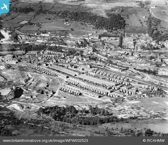
WPW032523 WALES (1930). General view of Treforest, oblique aerial view. 5"x4" black and white glass plate negative.
© Copyright OpenStreetMap contributors and licensed by the OpenStreetMap Foundation. 2026. Cartography is licensed as CC BY-SA.
Details
| Title | [WPW032523] General view of Treforest, oblique aerial view. 5"x4" black and white glass plate negative. |
| Reference | WPW032523 |
| Date | 1930 |
| Link | Coflein Archive Item 6370807 |
| Place name | |
| Parish | |
| District | |
| Country | WALES |
| Easting / Northing | 308500, 188500 |
| Longitude / Latitude | -3.3208841471314, 51.587442451582 |
| National Grid Reference | ST085885 |
Pins

redzep66 |
Thursday 25th of March 2021 08:00:27 PM | |
|
redzep66 |
Thursday 25th of March 2021 07:59:59 PM | |
|
redzep66 |
Thursday 25th of March 2021 07:59:25 PM | |
|
redzep66 |
Thursday 25th of March 2021 07:58:59 PM | |
|
redzep66 |
Thursday 25th of March 2021 07:58:10 PM | |
|
redzep66 |
Thursday 25th of March 2021 07:56:49 PM | |
|
steve |
Monday 22nd of February 2016 10:21:23 AM | |

Cwm458 |
Thursday 7th of August 2014 12:45:02 PM | |
|
Cwm458 |
Thursday 7th of August 2014 12:31:15 PM | |
|
Cwm458 |
Thursday 7th of August 2014 12:07:17 PM | |
|
Cwm458 |
Thursday 7th of August 2014 12:01:08 PM | |
|
Cwm458 |
Thursday 7th of August 2014 12:01:05 PM | |
|
Irregular Shed |
Friday 23rd of August 2013 01:19:57 PM | |
|
terry |
Tuesday 21st of August 2012 03:50:04 PM | |
|
terry |
Tuesday 21st of August 2012 03:49:03 PM | |
|
Alison Longman |
Thursday 19th of July 2012 10:42:53 PM | |
|
Alison Longman |
Thursday 19th of July 2012 10:42:10 PM | |
|
Alison Longman |
Thursday 19th of July 2012 10:40:04 PM | |
Machine Bridge, Because there was a Weigh Bridge on it |
Don1Estelle |
Wednesday 8th of August 2012 12:24:12 AM |
http://www.flickr.com/photos/thereggy/5404054859/ |
Don1Estelle |
Wednesday 8th of August 2012 01:15:39 AM |
This is the Machine Bridge, a weighing machine was installed on this bridge to weigh the coal from the first pits in the Rhondda valley. The coal was transported along a dram road pulled by ponies weighed on the bridge and then shipped by barge along the Glamorganshire Canal to Cardiff docks, the dram road and canal closed with the coming of the TVR. The dram road is still in existence and is now a cycle path. |
Cwm458 |
Thursday 7th of August 2014 12:43:24 PM |
|
Alison Longman |
Thursday 19th of July 2012 10:39:13 PM | |
|
Alison Longman |
Thursday 19th of July 2012 10:37:42 PM | |
|
Rob Daniels |
Thursday 19th of July 2012 12:45:11 PM | |
|
Topsin |
Sunday 1st of July 2012 05:20:09 AM | |
|
Topsin |
Sunday 1st of July 2012 05:13:58 AM | |
|
Topsin |
Sunday 1st of July 2012 05:10:36 AM | |
|
terry |
Tuesday 21st of August 2012 03:50:25 PM | |
|
dsl86 |
Friday 29th of June 2012 08:48:46 PM |
User Comment Contributions
The Duke of Bridgwater Arms |
steve |
Monday 22nd of February 2016 12:33:20 PM |
Thanks everyone for all the useful pins that help to show what's in the picture. "White Tips" looks like the remains of a defunct industrial landscape - can anyone cast any light on it for me? I'm not familiar with the area, it would be interesting to learn a bit more. Yours, Katy Britain from Above Cataloguing Team Leader |
Katy Whitaker |
Wednesday 3rd of October 2012 10:34:54 AM |