
WPW008700 WALES (1923) [Unlocated]
© Copyright OpenStreetMap contributors and licensed by the OpenStreetMap Foundation. 2026. Cartography is licensed as CC BY-SA.
Nearby Images (48)
EPW000143

EPW000667

EPW005260

EPW006389
, 1921")
EPW007181

EPW015853

EPW015854

EPW015855

EPW016012

EPW016510

EPW016641

EPW017028

EPW017029

EPW017136

SAW003585

SAW003586

SAW009337

SAW009800

SAW009801

SAW009802

SAW010734

SAW014737

SAW017926

SAW017927

SAW032504

SPW020275

SPW020280

SPW020281

SPW020284

SPW020632

SPW020633

SPW027083

SPW049776

SPW049777

SPW049779

SPW049783

SPW049791

SPW049798

SPW049801

SPW049827

SPW049828

SPW049831

SPW049832

SPW049834

SPW049948

SPW049949

SPW051009

SPW062638

Details
| Title | WPW008700 |
| Reference | WPW008700 |
| Date | 1923 |
| Link | |
| Place name | |
| Parish | |
| District | |
| Country | WALES |
| Easting / Northing | 0, 0 |
| Longitude / Latitude | -3.608485071124, 51.477633663022 |
| National Grid Reference | SS883767 |
Pins
User Comment Contributions
Hi Class31, thank you for sorting this one out. As it turns out to be a site in Wales it will take a little longer to make the changes to the record, because everything from the negative on the shelf to the scan and cataloguing need to be changed (involving physical moves as well as electronic ones!). Yours, Katy Britain from Above Cataloguing Team Leader |
Katy Whitaker |
Monday 1st of July 2013 01:08:17 PM |
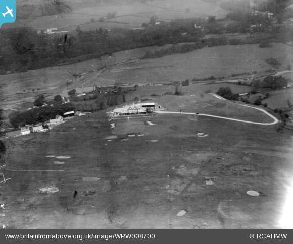
View looking north over Southerndown Golf Club and Ogmore Castle with Merthyr Mawr in the distance. |

Class31 |
Friday 3rd of May 2013 08:06:02 AM |
Eureka I am pretty sure that I have located this one of Southerndown Golf Club in South Wales.I have looked at photos of this area several months ago and that helped. Everything fits. Most of the bunkers are the same. |
Class31 |
Friday 3rd of May 2013 07:43:53 AM |