
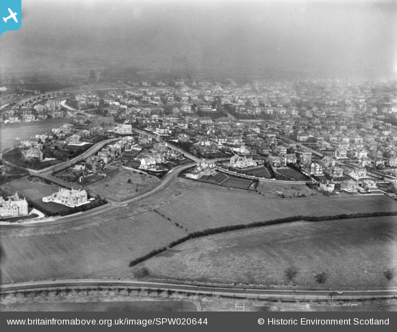
SPW020644 SCOTLAND (1928). Pollockshields, Glasgow, general view showing Dumbreck Road, Sherbrooke Avenue, and Springkell Avenue. An oblique aerial photograph taken facing north-east.
© Copyright OpenStreetMap contributors and licensed by the OpenStreetMap Foundation. 2026. Cartography is licensed as CC BY-SA.
Details
| Title | [SPW020644] Pollockshields, Glasgow, general view showing Dumbreck Road, Sherbrooke Avenue, and Springkell Avenue. An oblique aerial photograph taken facing north-east. |
| Reference | SPW020644 |
| Date | 1928 |
| Link | NRHE Collection item 1256402 |
| Place name | |
| Parish | GOVAN (CITY OF GLASGOW) |
| District | CITY OF GLASGOW |
| Country | SCOTLAND |
| Easting / Northing | 255890, 662780 |
| Longitude / Latitude | -4.3014063392875, 55.836715933911 |
| National Grid Reference | NS559628 |
Pins

camphill |
Thursday 3rd of October 2013 09:04:56 PM | |
|
Donald Marshall |
Wednesday 9th of January 2013 08:54:11 PM | |
|
Donald Marshall |
Wednesday 9th of January 2013 08:46:41 PM | |
|
Donald Marshall |
Wednesday 9th of January 2013 08:44:55 PM | |
|
Donald Marshall |
Wednesday 9th of January 2013 08:38:27 PM | |
|
Donald Marshall |
Wednesday 9th of January 2013 08:35:33 PM | |
|
Donald Marshall |
Wednesday 9th of January 2013 08:34:18 PM | |
|
Donald Marshall |
Wednesday 9th of January 2013 08:24:36 PM | |
|
Donald Marshall |
Wednesday 9th of January 2013 08:23:21 PM | |
|
Southsider |
Saturday 21st of July 2012 09:26:31 PM | |
|
mannidaze |
Monday 16th of July 2012 09:43:33 PM | |
|
BigglesH |
Monday 9th of July 2012 03:38:03 AM | |
|
BigglesH |
Monday 9th of July 2012 03:29:37 AM | |
It is actually Dumbreck road. There are small trees planted alongside Cartha Rugby Club which give the apperarnce of sleepers |
Southsider |
Saturday 21st of July 2012 09:23:43 PM |
|
BenR |
Sunday 8th of July 2012 07:48:28 PM | |
Cartha RFC |
Southsider |
Saturday 21st of July 2012 09:24:12 PM |
|
BenR |
Sunday 8th of July 2012 07:48:04 PM | |
The church is Sherbrooke Church at the junction of Nithsdale Rd and Sherbrooke Avenue; and the other building is Sherbrooke Hotel (now renamed Sherbrooke Castle Hotel for obvious reasons. |
Southsider |
Saturday 21st of July 2012 09:22:04 PM |
|
BenR |
Sunday 8th of July 2012 07:47:04 PM | |
St Gilberts Church..Nithsdale Road..Pollokshields. |
Danny55 |
Saturday 28th of July 2012 07:29:51 AM |
St Gilberts Church..Nithsdale Road..Pollokshields. |
Danny55 |
Saturday 28th of July 2012 07:30:10 AM |
User Comment Contributions
Dear all, That's great; we've reviewed your comments and thanks to your help we can update the catalogue. The revised record will appear here in due course. Hope you have the same success solving some of our other mysteries! Brian Wilkinson Britain from Above Activity Officer (Scotland) |
Brian Wilkinson |
Wednesday 9th of January 2013 08:52:46 PM |
Yeah, it's a view of West Pollokshields (the very west part) looking north, with Dumbreck Road in the foreground. You can almost make out Princes Dock in the gloom at the top! |
Donald Marshall |
Wednesday 9th of January 2013 08:52:46 PM |
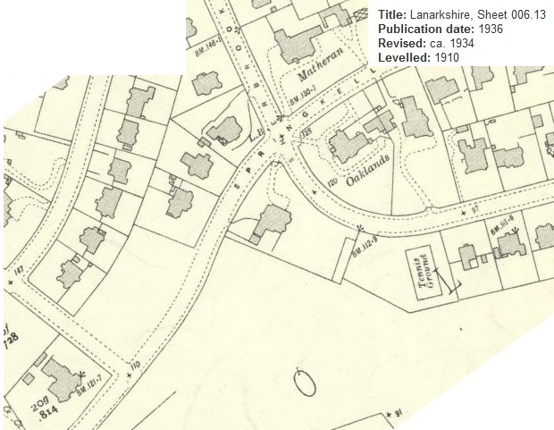
Now the 1934 map... |
ewnmcg |
Friday 20th of July 2012 08:06:11 PM |
Previous map attachment too big? Let's try one at a time. |
ewnmcg |
Friday 20th of July 2012 08:04:07 PM |
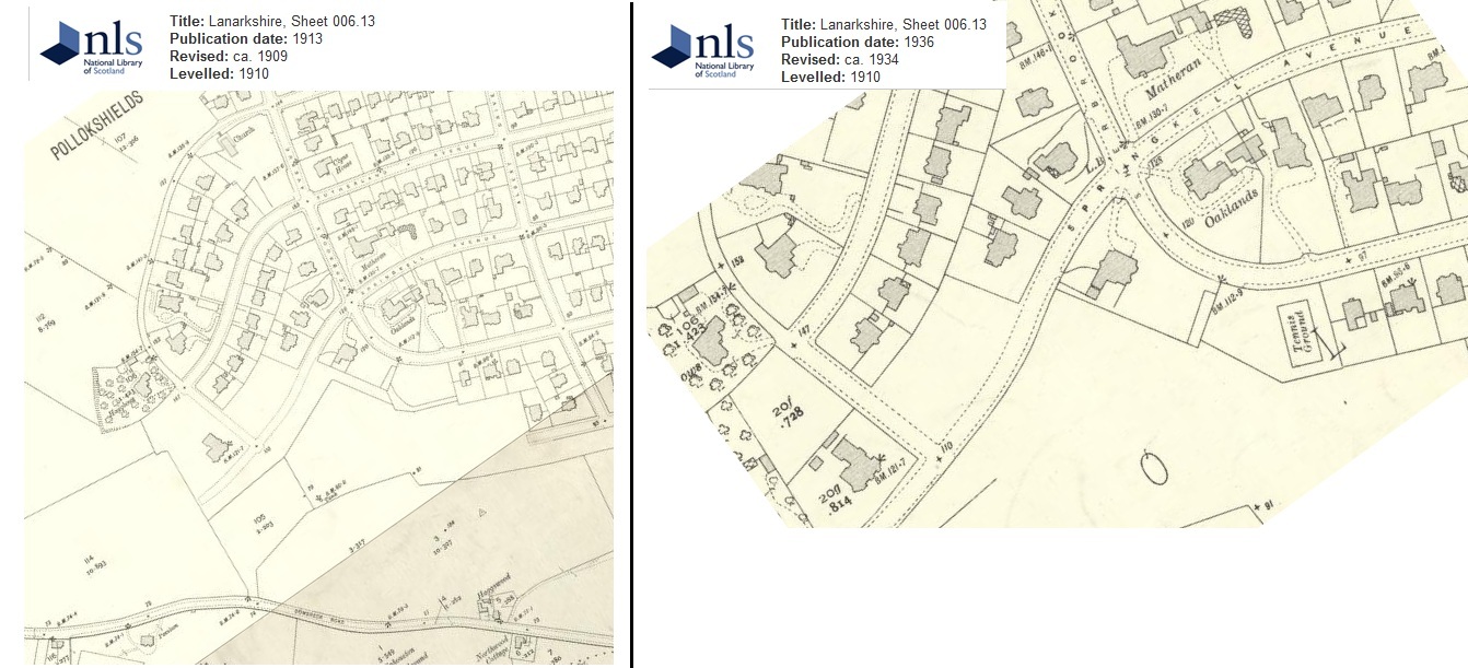
Sorry - here are the missing maps from earlier comment. |
ewnmcg |
Friday 20th of July 2012 08:00:28 PM |
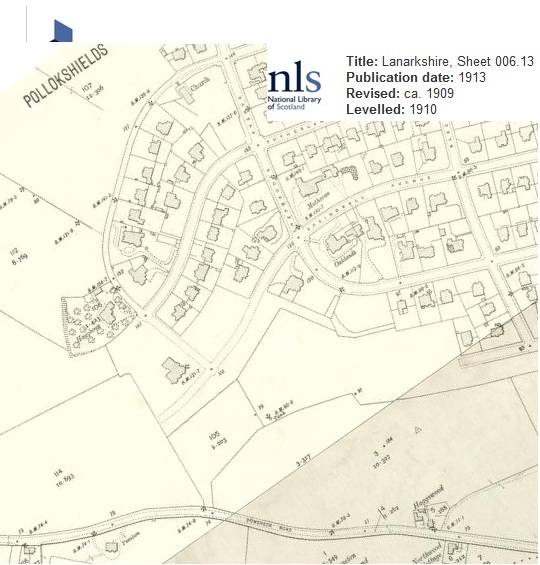
I agree with Sarah - well done. I attach two maps 1909 and 1934. There are so many 'matches'. The layout of the driveways at 'Oaklands' and nearby houses; the 'kink' in the field boundary on the 1909 map - appears on the photo; Dumbreck Road at bottom winding gently along. |
ewnmcg |
Friday 20th of July 2012 07:59:32 PM |
Sorry, Springkell Avenue. |
Sarah |
Friday 20th of July 2012 12:05:38 AM |
I think the Church with the two turrets is on Nithsdale Road, Pollokshields near the junction with Sherbrooke Drive/Avenue. Then I think the crossroads in the foreground is the junction of Sherbrooke Avenue and Springkell Road - the 4 big houses on the junction all look right - and the road in the foreground is Dumbreck Road. (using Bing maps Bird's Eye - too many trees on Google.) |
Sarah |
Friday 20th of July 2012 12:04:38 AM |
Wondering if smooth line at bottom is a canal? My thinking is that most cars used to be black/dark. Is it maybe a boat? I've also been thinking about the Knightswood/Bearsden area but the sheer number of very large houses (many three storeys) makes me think this is unlikely. I've not yet ruled it out though. |
ewnmcg |
Wednesday 18th of July 2012 01:59:56 PM |
According to the photo numbering, this is between High Knightswood Housing Estate (Glasgow) and Bearsden |
BenR |
Sunday 8th of July 2012 07:57:24 PM |