
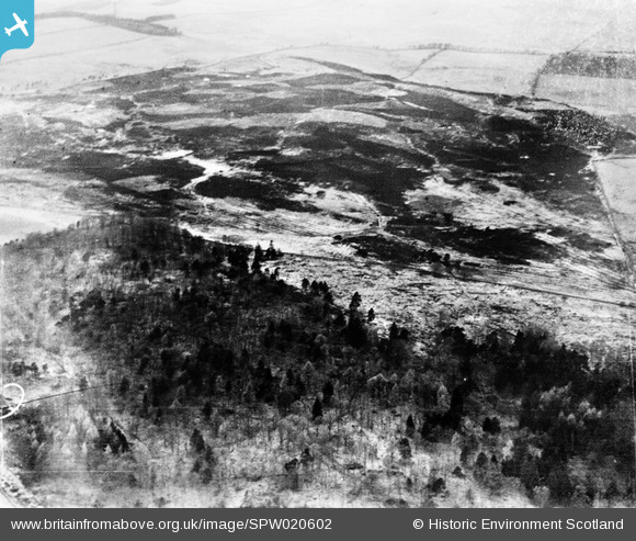
SPW020602 SCOTLAND (1928). Mugdock Country Park, general view showing Mugdock Wood and Mugdock Loch. An oblique aerial photograph taken facing north.
© Copyright OpenStreetMap contributors and licensed by the OpenStreetMap Foundation. 2026. Cartography is licensed as CC BY-SA.
Details
| Title | [SPW020602] Mugdock Country Park, general view showing Mugdock Wood and Mugdock Loch. An oblique aerial photograph taken facing north. |
| Reference | SPW020602 |
| Date | 1928 |
| Link | NRHE Collection item 1256370 |
| Place name | |
| Parish | STRATHBLANE (STIRLING) |
| District | STIRLING |
| Country | SCOTLAND |
| Easting / Northing | 255000, 676000 |
| Longitude / Latitude | -4.322690392202, 55.955145613289 |
| National Grid Reference | NS550760 |
Pins

Class31 |
Thursday 27th of September 2012 07:35:20 PM | |
|
Class31 |
Thursday 27th of September 2012 07:33:10 PM | |
|
Class31 |
Thursday 27th of September 2012 07:24:24 PM | |
|
Class31 |
Thursday 27th of September 2012 07:21:51 PM | |
|
Class31 |
Thursday 27th of September 2012 07:19:22 PM | |
|
Class31 |
Thursday 27th of September 2012 07:16:05 PM | |
|
Class31 |
Thursday 27th of September 2012 07:12:47 PM |
User Comment Contributions
I was able to identify this photograph by checking the photograph with numbers before and after this photo ie SPW020601 and SPW020603. I was able to see that the trees in the wood in both SPW 020601 and SPW020602 looked similar so I started a check in detail. Very soon things fell into place. It required an act of faith to identify Mugdock Loch which initially looked just like a field. When you examine it carefully against the map you find that it is the right shape. everything else fits in. The photo is taken looking north. There is a lochan just to the north of Mugdock Loch which is the right shape. North of that is the line of the Craigallian Road. Over to the right we have a field boundary and road leading up to South Lodge. Across the middle of the image we have a diagonal boundary which can be seen both on the 1:500000 OS map and on Google maps satellite view. There is also a distinctive shaped clearing which may be seen on Google. I am very happy with this identification because everything fits and the previous shot SPW020601 is in the same area. I have spent much time trying to identify the dwindling number of unidentified shots but this one took very little time in the end. |
Class31 |
Thursday 11th of October 2012 11:44:44 PM |
In line two above where I say SPW020601 for the second time it should be SPW020603. Thanks |
Class31 |
Thursday 27th of September 2012 07:58:19 PM |
Hello Class31, Many thanks for your thoughts regarding this image. This image has been passed on to the cataloging who will resolve the issue. |

Matthew Faber |
Friday 5th of October 2012 03:49:05 PM |
Thanks for this! I have put in a request to update the record, and the corrected details will appear here in due course. Best wishes, Brian Wilkinson Britain from Above Activity Officer (Scotland) |
Brian Wilkinson |
Thursday 11th of October 2012 12:33:30 PM |
Thank you Brian for your kind comments. |
Class31 |
Thursday 11th of October 2012 11:44:44 PM |
Eureka |
Class31 |
Thursday 27th of September 2012 07:06:30 PM |