
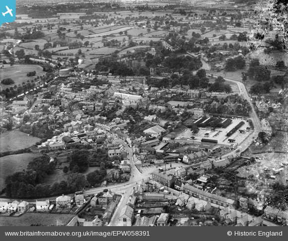
EPW058391 ENGLAND (1938). The town, Whitchurch, from the east, 1938. This image has been produced from a damaged negative.
© Copyright OpenStreetMap contributors and licensed by the OpenStreetMap Foundation. 2026. Cartography is licensed as CC BY-SA.
Details
| Title | [EPW058391] The town, Whitchurch, from the east, 1938. This image has been produced from a damaged negative. |
| Reference | EPW058391 |
| Date | 28-July-1938 |
| Link | |
| Place name | WHITCHURCH |
| Parish | WHITCHURCH URBAN |
| District | |
| Country | ENGLAND |
| Easting / Northing | 354507, 341544 |
| Longitude / Latitude | -2.6774679216497, 52.969010151793 |
| National Grid Reference | SJ545415 |
Pins

Class31 |
Tuesday 3rd of May 2016 06:08:27 PM | |

Martin |
Thursday 20th of February 2014 12:28:52 PM | |
|
Martin |
Thursday 20th of February 2014 12:27:34 PM | |
|
Martin |
Thursday 20th of February 2014 12:26:26 PM | |
|
Martin |
Thursday 20th of February 2014 12:25:52 PM | |
|
Martin |
Thursday 20th of February 2014 12:25:33 PM | |
|
Martin |
Thursday 20th of February 2014 11:42:06 AM | |
|
Martin |
Thursday 20th of February 2014 11:40:52 AM | |
|
Martin |
Thursday 20th of February 2014 11:40:14 AM | |
|
Martin |
Thursday 20th of February 2014 11:39:01 AM | |
|
Martin |
Thursday 20th of February 2014 11:38:31 AM | |
|
Martin |
Thursday 20th of February 2014 11:37:16 AM | |
|
Martin |
Thursday 20th of February 2014 11:36:16 AM | |
|
Martin |
Thursday 20th of February 2014 11:32:29 AM | |
|
Martin |
Thursday 20th of February 2014 11:32:03 AM | |
|
Martin |
Thursday 20th of February 2014 11:29:49 AM |
