
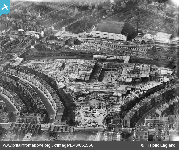
EPW051550 ENGLAND (1936). The Earls Court Exhibition Centre under construction, Earl's Court, 1936
© Copyright OpenStreetMap contributors and licensed by the OpenStreetMap Foundation. 2026. Cartography is licensed as CC BY-SA.
Nearby Images (48)
EPW052936
 under construction, Earl's Court, 1937")
EPW052932
 under construction, Earl's Court, 1937")
EPW055909

EPW053627
 under construction, Earl's Court, 1937")
EPW052253

EPW053626
 under construction, Earl's Court, 1937")
EPW051915

EPW051910

EPW052783

EPW051911

EPW053628
 under construction, Earl's Court, 1937")
EAW000107

EPW052251

EPW052931
 under construction, Earl's Court, 1937")
EPW052395
 under construction, Earl's Court, 1937. This image has been produced from a copy-negative.")
EPW052533

EPW053636
 under construction, Earl's Court, 1937")
EPW053629
 under construction, Earl's Court, 1937")
EPW052933
 under construction, Earl's Court, 1937")
EPW052944
 under construction, Earl's Court, 1937")
EPW052787

EPW024261

EPW052791

EPW055290

EPW051916

EPW059934

EPW051554

EPW053634
 under construction, Earl's Court, 1937")
EPW052789

EPW024262

EPW053633
 under construction, Earl's Court, 1937")
EPW053632
 under construction, Earl's Court, 1937")
EPW051912

EPW054649

EPW054650

EPW051913

EPW052786

EPW054652

EPW055902

EPW054657

EPW055901

EAW022044

EPW051556

EPW051555

EAW015275

EPW055904

EPW055910

EPW055900

Details
| Title | [EPW051550] The Earls Court Exhibition Centre under construction, Earl's Court, 1936 |
| Reference | EPW051550 |
| Date | August-1936 |
| Link | |
| Place name | EARL'S COURT |
| Parish | |
| District | |
| Country | ENGLAND |
| Easting / Northing | 525261, 178196 |
| Longitude / Latitude | -0.19563831689603, 51.488336010193 |
| National Grid Reference | TQ253782 |
Pins


User Comment Contributions

Earls Court Exhibition Centre, 23/09/2014 |

Class31 |
Saturday 15th of November 2014 08:17:40 AM |