
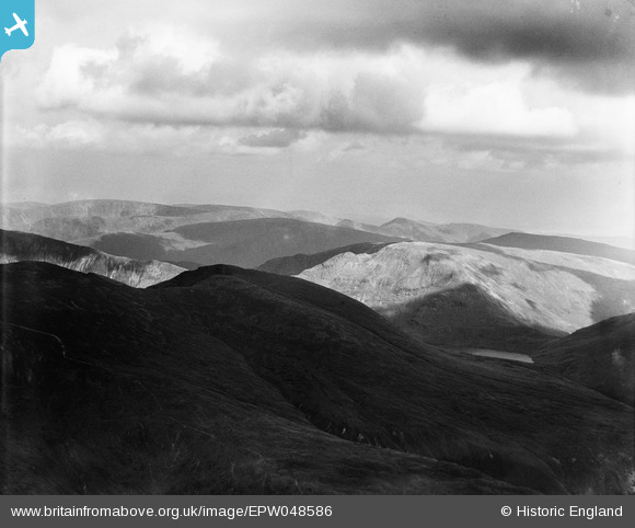
EPW048586 ENGLAND (1935). Peaks above Haweswater Reservoir, Kidsty Pike, from the north-west, 1935
© Copyright OpenStreetMap contributors and licensed by the OpenStreetMap Foundation. 2026. Cartography is licensed as CC BY-SA.
Details
| Title | [EPW048586] Peaks above Haweswater Reservoir, Kidsty Pike, from the north-west, 1935 |
| Reference | EPW048586 |
| Date | July-1935 |
| Link | |
| Place name | KIDSTY PIKE |
| Parish | BAMPTON |
| District | |
| Country | ENGLAND |
| Easting / Northing | 344966, 512656 |
| Longitude / Latitude | -2.8500133531456, 54.506096250693 |
| National Grid Reference | NY450127 |
Pins

JEM |
Tuesday 10th of December 2013 08:29:47 PM | |
|
JEM |
Tuesday 10th of December 2013 08:25:00 PM | |
|
JEM |
Tuesday 10th of December 2013 08:24:37 PM | |

Class31 |
Friday 31st of May 2013 10:45:39 AM | |
This looks to be Red Screes. |
JEM |
Tuesday 10th of December 2013 08:20:58 PM |
|
Class31 |
Friday 31st of May 2013 10:36:18 AM | |
This is Dollywaggon Pike. |
JEM |
Tuesday 10th of December 2013 08:21:30 PM |
Katy Whitaker |
Friday 31st of May 2013 10:20:47 AM | |
Yes That's the thought, Katy. I'm trying to get my head round it all. |
Class31 |
Friday 31st of May 2013 10:38:11 AM |
This is Fairfield. |
JEM |
Tuesday 10th of December 2013 08:18:52 PM |
|
Class31 |
Friday 31st of May 2013 10:13:26 AM | |
This is the western slope of Helvellyn. |
JEM |
Tuesday 10th of December 2013 08:26:59 PM |
|
Class31 |
Friday 31st of May 2013 10:07:08 AM | |
This is actually grisedale tarn. |
JEM |
Tuesday 10th of December 2013 08:18:08 PM |
User Comment Contributions
This is wrongly identified - it is actually taken from a point to the west of Helvellyn looking in a south easterly direction. The water is Grisedale Tarn. |
JEM |
Tuesday 10th of December 2013 08:14:30 PM |
Thank you... The original Aerofilms Ltd Register entry for the image says "Areas in the Lake District for Manchester Corporation Waterworks"; as you know we simply don't have enough leeway with our time to be able to hunt images like this out. It makes such a difference that website members can help with these. We'll update the catalogue and post the new record here in due course. Yours, Katy Britain from Above Cataloguing Team Leader |
Katy Whitaker |
Tuesday 2nd of July 2013 01:09:31 PM |
I am confident of the Haweswater Reservoir location together with those locations further from the camera. |
Class31 |
Friday 31st of May 2013 10:59:00 AM |
This is so difficult because of the wildness of the terrain and the limited research resources available to me. I am using a. a 1 inch Lake District OS map.b. A Wainwright Apictorial Guide to the Lake District Book Two "The Far Eastern Fells" Old Maps which in this case is pretty useless and Streetmap which is likely to show boundary walls. |
Class31 |
Friday 31st of May 2013 10:19:23 AM |