
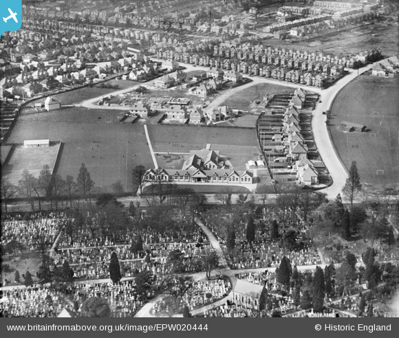
EPW020444 ENGLAND (1928). Atherley School and Southampton Cemetery, Southampton, from the east, 1928
© Copyright OpenStreetMap contributors and licensed by the OpenStreetMap Foundation. 2026. Cartography is licensed as CC BY-SA.
Details
| Title | [EPW020444] Atherley School and Southampton Cemetery, Southampton, from the east, 1928 |
| Reference | EPW020444 |
| Date | 16-March-1928 |
| Link | |
| Place name | SOUTHAMPTON |
| Parish | |
| District | |
| Country | ENGLAND |
| Easting / Northing | 441230, 113620 |
| Longitude / Latitude | -1.4133732056425, 50.920014222146 |
| National Grid Reference | SU412136 |
Pins

ARussel |
Saturday 18th of September 2021 10:02:54 PM | |
|
ARussel |
Saturday 18th of September 2021 10:00:28 PM | |
|
ARussel |
Saturday 18th of September 2021 09:53:11 PM | |
|
Angela S |
Friday 22nd of May 2020 08:25:50 PM | |
|
KeithFP |
Friday 21st of December 2018 11:29:29 PM | |
|
KeithFP |
Friday 21st of December 2018 11:28:17 PM | |
|
KeithFP |
Friday 21st of December 2018 11:27:25 PM | |
|
Richard Hampshire |
Sunday 28th of February 2016 09:33:47 PM | |

Class31 |
Monday 6th of August 2012 09:10:52 AM | |
|
Class31 |
Monday 6th of August 2012 09:09:43 AM | |
|
Class31 |
Monday 6th of August 2012 09:09:07 AM | |
|
Class31 |
Monday 6th of August 2012 09:07:59 AM | |
|
Tipps |
Wednesday 18th of July 2012 09:15:39 PM | |
|
Marc |
Monday 9th of July 2012 07:39:15 PM | |
It was King Edward VI School! |
Tipps |
Wednesday 18th of July 2012 09:27:28 PM |
Confirm Tipps' comment - King Edward VI not King Alfred. KES is still on same site, Atherley School has moved. |
Sailor Steve |
Sunday 11th of August 2013 09:12:23 PM |
|
Marc |
Monday 9th of July 2012 07:37:55 PM | |
I remember the cemetery well - we used to walk through it on our way to The Common in the 70s. It was little visited, overgrown and a great place for seeing woodpeckers. |
Tipps |
Wednesday 18th of July 2012 09:29:48 PM |
User Comment Contributions
This is a fascinating photograph as it shows the early development of Evelyn Crescent, a mix of mainly 3 bed semis with some larger detached houses on the corners. The broad sweeping road to the left of the photo is the lower part of Wilton Rd which runs in front of King Edward VI School which wasn't built when this photo was taken. Hill Lane lies between The Cemetery and The Atherley School which was demolished in the late 1990s and the site subsequently redeveloped with housing. |
Tipps |
Saturday 27th of October 2012 10:05:59 AM |
If you look closely at the field to the right of Wilton road, its possible to see goal posts of football pitches, which is very likely the playing field of King Edward VI School. |
SaintMarysSaint |
Saturday 27th of October 2012 10:05:59 AM |
We moved into Evelyn crescent in 1986 and are still here! Our house is not built yet in this photo but our next door neighbour's is! |
Slock |
Sunday 16th of September 2012 09:38:43 AM |