
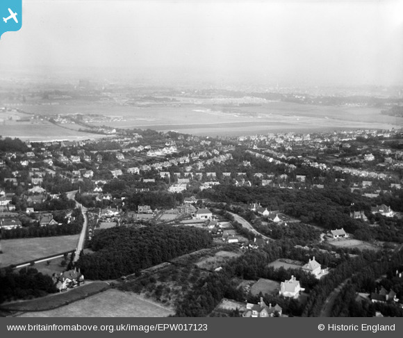
EPW017123 ENGLAND (1926). Briar Hill and environs looking towards Croydon Airport, Woodcote, from the south-west, 1926
© Copyright OpenStreetMap contributors and licensed by the OpenStreetMap Foundation. 2026. Cartography is licensed as CC BY-SA.
Details
| Title | [EPW017123] Briar Hill and environs looking towards Croydon Airport, Woodcote, from the south-west, 1926 |
| Reference | EPW017123 |
| Date | October-1926 |
| Link | |
| Place name | WOODCOTE |
| Parish | |
| District | |
| Country | ENGLAND |
| Easting / Northing | 530228, 161765 |
| Longitude / Latitude | -0.13016633260548, 51.339534686039 |
| National Grid Reference | TQ302618 |
Pins

Mike |
Tuesday 25th of July 2023 06:50:08 PM | |
|
Mike |
Tuesday 25th of July 2023 06:48:42 PM | |
|
longshot |
Thursday 13th of December 2012 10:25:04 PM | |
|
longshot |
Thursday 13th of December 2012 10:21:17 PM | |
|
longshot |
Thursday 13th of December 2012 10:16:49 PM | |
|
longshot |
Thursday 13th of December 2012 10:15:17 PM | |

Class31 |
Tuesday 4th of December 2012 01:19:37 PM | |
|
Class31 |
Tuesday 4th of December 2012 12:58:33 PM | |
|
Class31 |
Tuesday 4th of December 2012 12:57:56 PM | |
|
Class31 |
Tuesday 4th of December 2012 12:57:30 PM | |
|
Class31 |
Tuesday 4th of December 2012 12:55:48 PM | |
|
Class31 |
Tuesday 4th of December 2012 12:52:08 PM | |
|
Class31 |
Tuesday 4th of December 2012 12:49:56 PM | |
|
Class31 |
Tuesday 4th of December 2012 12:38:30 PM | |
|
Dave T |
Monday 26th of November 2012 12:03:47 PM | |
|
HydeParkDave |
Monday 16th of July 2012 11:29:59 PM | |
|
BigglesH |
Tuesday 26th of June 2012 04:13:27 PM | |
If you walked downn The Bridle Road from Plough Lane and crossed over, the Gated estate was Rose Walk. |
Aquarias |
Saturday 21st of December 2013 12:56:45 AM |
|
BigglesH |
Tuesday 26th of June 2012 04:12:24 PM |
User Comment Contributions
This is a shot taken looking north east from above Silver Lane Woodcote looking over Foxley Lane towards Croydon Aerodrome. Middle of shot is about the junction of The Bridle Road with Plough Lane. This is a confirmed identification in that everything fits. There are few large aircraft hangars in the UK in 1926. The gated roads in the exclusive housing in the foreground is also unusual. The roads all fit the photo. It is a while since I was able to identify an unidentified photo. Whoop. |
Class31 |
Wednesday 2nd of January 2013 11:14:03 AM |
Thanks Class31, We'll update the location details and load the new, correct data, in due course. Yours, Katy Britain from Above Cataloguing Team Leader |
Katy Whitaker |
Wednesday 2nd of January 2013 11:14:03 AM |
(And the Plough Lane terminal remained in use until 1928) |
longshot |
Thursday 13th of December 2012 10:27:31 PM |
(And the Plough Lane terminal remained in use until 1928) |
longshot |
Thursday 13th of December 2012 10:27:30 PM |
It is early days but this looks to be Croydon Aerodrome. The sign on the hangar looks to be ADC Aircraft Ltd. as seen in photograph EPW025102 |
Class31 |
Tuesday 4th of December 2012 12:32:25 PM |
Eureka |
Class31 |
Tuesday 4th of December 2012 12:28:57 PM |
There is lettering on the large building just beyond what might be an airfield. Possibly ??? FLIGHTS LTD |
PaulMcCombie |
Friday 17th of August 2012 06:39:28 PM |
Places like this always end up being Bournemouth |
Survey of London historian |
Tuesday 7th of August 2012 11:12:52 AM |