
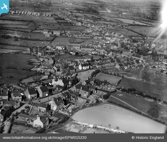
EPW015230 ENGLAND (1926). The High Street, Cheslyn Hay, 1926
© Copyright OpenStreetMap contributors and licensed by the OpenStreetMap Foundation. 2026. Cartography is licensed as CC BY-SA.
Details
| Title | [EPW015230] The High Street, Cheslyn Hay, 1926 |
| Reference | EPW015230 |
| Date | 13-April-1926 |
| Link | |
| Place name | CHESLYN HAY |
| Parish | CHESLYN HAY |
| District | |
| Country | ENGLAND |
| Easting / Northing | 397665, 306964 |
| Longitude / Latitude | -2.0345262030736, 52.660044058867 |
| National Grid Reference | SJ977070 |
Pins

SteveB09 |
Saturday 22nd of April 2023 09:30:10 AM | |
|
SteveB09 |
Saturday 22nd of April 2023 09:18:01 AM | |
|
SteveB09 |
Saturday 22nd of April 2023 09:16:42 AM | |
|
SteveB09 |
Friday 21st of April 2023 04:15:28 PM | |
|
SteveB09 |
Friday 21st of April 2023 04:13:39 PM | |
|
SIB1 |
Wednesday 8th of October 2014 09:46:13 AM | |
|
SIB1 |
Wednesday 6th of August 2014 09:13:07 PM | |
|
SIB1 |
Wednesday 6th of August 2014 09:02:47 PM | |
|
SIB1 |
Wednesday 6th of August 2014 08:39:30 PM | |
|
SIB1 |
Wednesday 6th of August 2014 07:56:16 PM | |
|
SIB1 |
Wednesday 6th of August 2014 07:54:41 PM | |
|
jungdave |
Monday 23rd of December 2013 09:03:11 PM | |
|
hacksaw065 |
Monday 28th of January 2013 06:13:36 PM | |
|
hacksaw065 |
Monday 28th of January 2013 06:12:14 PM | |
|
hacksaw065 |
Monday 28th of January 2013 06:11:14 PM | |
|
hacksaw065 |
Monday 28th of January 2013 06:10:20 PM |