
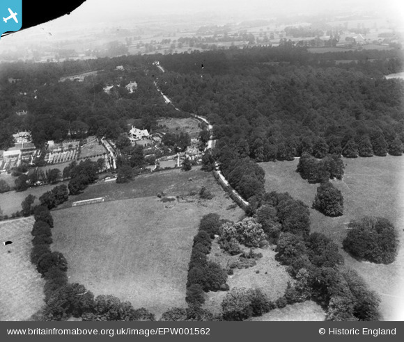
EPW001562 ENGLAND (1920). Sandy Lane, Oxhey Wood, from the south, 1920
© Copyright OpenStreetMap contributors and licensed by the OpenStreetMap Foundation. 2026. Cartography is licensed as CC BY-SA.
Details
| Title | [EPW001562] Sandy Lane, Oxhey Wood, from the south, 1920 |
| Reference | EPW001562 |
| Date | June-1920 |
| Link | |
| Place name | OXHEY WOODS |
| Parish | |
| District | |
| Country | ENGLAND |
| Easting / Northing | 510592, 191693 |
| Longitude / Latitude | -0.40260416445598, 51.612719636001 |
| National Grid Reference | TQ106917 |
Pins

John Swain |
Monday 2nd of September 2013 04:07:30 PM | |
|
John Swain |
Monday 2nd of September 2013 04:05:30 PM | |
|
John Swain |
Monday 2nd of September 2013 04:03:37 PM | |
|
John Swain |
Monday 2nd of September 2013 04:01:27 PM | |
|
John Swain |
Monday 2nd of September 2013 04:00:02 PM | |
|
John Swain |
Monday 2nd of September 2013 03:57:52 PM | |
|
John Swain |
Monday 2nd of September 2013 03:56:20 PM | |
|
John Swain |
Monday 2nd of September 2013 03:55:04 PM |
User Comment Contributions
i like the that you can see the footpath leading to the oxhey pavillion and warren dell house, still there today but now swamped in context and only the pitch and put remaining |

This is six |
Thursday 17th of January 2013 12:54:03 PM |
The road running up the centre of the photo is Oxhey Drive, with Sandy Lane almost invisible branching off to the left at 45 degrees immediately after the first house from the bottom. Before this branch, the road is Potter Street Hill. Immediately after the branch, on the right side of Oxhey Drive there is now a covered resevoir. Running horizontally across the whole centre of the photo passing just below the first house) is the Middlesex (bottom) Hertfordshire border |
Blueberry |
Saturday 27th of October 2012 08:08:10 PM |
An early image of the rural zone between Northwood (Middlesex) and Watford (Herts), with Sandy Lane cutting through Oxhey Woods to the right of picture and the Eastbury Estate to the left. In the background, the long-established woodland gives way to farmland on the northern slopes of the South Herts Plateau, much of which forms part of the Blackwell Estate. In recent years before the photograph was taken, golf courses were opened at Sandy Lodge (1910) and Oxhey (1912), with the road running in a northerly direction between them. |
John Swain |
Tuesday 10th of July 2012 03:43:06 PM |