
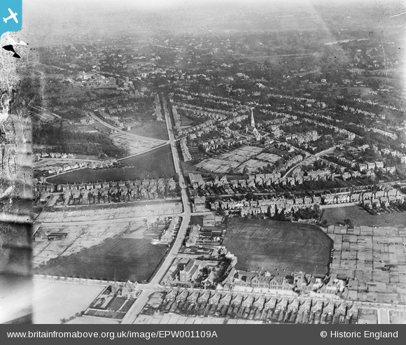
EPW001109A ENGLAND (1920). Portland Road and environs including St Augustine's Church, Birmingham, from the north-west, 1920
© Copyright OpenStreetMap contributors and licensed by the OpenStreetMap Foundation. 2026. Cartography is licensed as CC BY-SA.
Details
| Title | [EPW001109A] Portland Road and environs including St Augustine's Church, Birmingham, from the north-west, 1920 |
| Reference | EPW001109A |
| Date | May-1920 |
| Link | |
| Place name | BIRMINGHAM |
| Parish | |
| District | |
| Country | ENGLAND |
| Easting / Northing | 403319, 286573 |
| Longitude / Latitude | -1.9511282221039, 52.476706100933 |
| National Grid Reference | SP033866 |
Pins

Griffin |
Thursday 5th of November 2015 11:15:53 PM | |
|
Griffin |
Thursday 5th of November 2015 10:30:31 PM | |
|
Griffin |
Thursday 5th of November 2015 10:29:37 PM | |
|
PURCELL |
Tuesday 19th of November 2013 04:31:35 PM | |
|
PURCELL |
Tuesday 19th of November 2013 04:30:19 PM | |
|
PURCELL |
Tuesday 19th of November 2013 04:29:34 PM | |
|
Hauntboy |
Saturday 13th of July 2013 01:13:02 AM | |
|
Hauntboy |
Saturday 13th of July 2013 01:03:03 AM | |
|
Hauntboy |
Saturday 13th of July 2013 01:01:55 AM | |
|
Humph3 |
Saturday 1st of September 2012 03:00:54 PM | |
|
Steve Cemm |
Tuesday 10th of July 2012 05:54:22 PM | |
|
Steve Cemm |
Tuesday 10th of July 2012 05:53:46 PM | |
|
Steve Cemm |
Tuesday 10th of July 2012 05:53:03 PM | |
|
Steve Cemm |
Tuesday 10th of July 2012 05:52:25 PM | |
|
madanorak |
Thursday 5th of July 2012 10:42:34 PM | |
|
Ron41 |
Thursday 5th of July 2012 08:26:07 PM | |
|
wakegreen |
Wednesday 4th of July 2012 08:36:17 PM | |
|
wakegreen |
Wednesday 4th of July 2012 08:34:25 PM | |
|
wakegreen |
Wednesday 4th of July 2012 08:33:11 PM | |
|
EastMarple1 |
Saturday 30th of June 2012 12:13:48 PM | |
This is th Oratory on Hagley Rd |
madanorak |
Thursday 5th of July 2012 10:44:28 PM |
|
EastMarple1 |
Saturday 30th of June 2012 12:12:29 PM | |
I have looked at all of your comments and not one actually informs. What lake is it? what church is? If you don't know please don't clog the picture up with meaningless comments. Thanks. This is not meant to sound nasty, sorry if it does) |
Humph3 |
Saturday 1st of September 2012 02:57:53 PM |
|
EastMarple1 |
Saturday 30th of June 2012 12:10:33 PM | |
This was the playing field of King Edwards Grammar School, Five Ways,Birmingham. The school relocated to Bartley Green in 1958. |
MartinN |
Tuesday 11th of December 2012 11:37:56 AM |
|
EastMarple1 |
Saturday 30th of June 2012 12:09:32 PM | |
|
BigglesH |
Wednesday 27th of June 2012 03:12:40 PM | |
|
BigglesH |
Tuesday 26th of June 2012 02:32:09 AM | |
St Augustines Church |
Ron41 |
Thursday 5th of July 2012 08:23:26 PM |
|
BigglesH |
Tuesday 26th of June 2012 02:31:09 AM | |
IN OLD MAPS THIS WAS 'THE CHAPEL OF THE REDEEMER' (GEN. BAP.) THIS WAS DEMOLISHED AND THE SITE IS NOW OCCUPIED BY FLATS. |
Griffin |
Thursday 5th of November 2015 11:01:58 PM |

User Comment Contributions
Ladywood, Birmingham. The church in the foreground is St. Augustine's Church and the "Light coloured stone building" is The Oratory, Edgbaston. The convergence of the two main roads are the A456 and B4129. The distinctive church is no longer. |
john m fallas |
Monday 2nd of July 2012 12:42:19 PM |
Dear john m fallas, That’s great; we’ve reviewed your comment and thanks to your help we can update the catalogue. The revised record will appear here in due course. Hope you have the same success solving some of our other mysteries! Katy Whitaker Britain from Above Cataloguer |
Katy Whitaker |
Monday 2nd of July 2012 12:42:19 PM |
Likely to be in the West Bromwich or Hockley areas if the image numbers are in sequence. |

Class31 |
Wednesday 27th of June 2012 04:15:45 PM |