
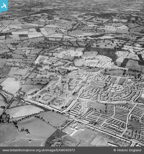
EAW040972 ENGLAND (1951). Construction of the Harold Hill Estate, Harold Hill, 1951
© Copyright OpenStreetMap contributors and licensed by the OpenStreetMap Foundation. 2026. Cartography is licensed as CC BY-SA.
Details
| Title | [EAW040972] Construction of the Harold Hill Estate, Harold Hill, 1951 |
| Reference | EAW040972 |
| Date | 23-October-1951 |
| Link | |
| Place name | HAROLD HILL |
| Parish | |
| District | |
| Country | ENGLAND |
| Easting / Northing | 553789, 192518 |
| Longitude / Latitude | 0.22126326446492, 51.609989883366 |
| National Grid Reference | TQ538925 |
Pins

jonnyace |
Saturday 30th of August 2025 11:32:32 PM | |
|
jonnyace |
Saturday 30th of August 2025 11:31:09 PM | |
|
jonnyace |
Saturday 30th of August 2025 11:28:41 PM | |
|
jonnyace |
Saturday 30th of August 2025 11:27:29 PM | |
|
jonnyace |
Saturday 30th of August 2025 11:25:35 PM | |
|
jonnyace |
Friday 29th of December 2023 11:03:15 PM | |
|
jonnyace |
Friday 29th of December 2023 11:02:41 PM | |
|
jonnyace |
Friday 29th of December 2023 11:01:39 PM | |
|
jonnyace |
Friday 29th of December 2023 11:00:38 PM | |
|
jonnyace |
Friday 29th of December 2023 11:00:05 PM | |
|
jonnyace |
Friday 29th of December 2023 10:59:14 PM | |
|
jonnyace |
Friday 29th of December 2023 10:57:17 PM | |
|
jonnyace |
Friday 29th of December 2023 10:55:34 PM | |
|
jonnyace |
Friday 29th of December 2023 10:53:18 PM | |
|
jonnyace |
Friday 29th of December 2023 10:50:42 PM | |
|
jonnyace |
Friday 29th of December 2023 10:47:15 PM | |
|
Post-war prefabs |
Saturday 2nd of November 2019 08:17:11 AM | |
|
steman74 |
Monday 28th of November 2016 08:46:12 AM | |
|
steman74 |
Monday 28th of November 2016 08:45:02 AM |