
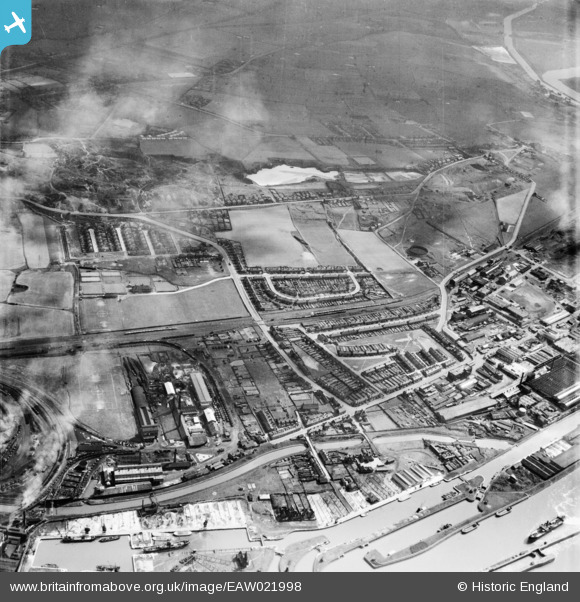
EAW021998 ENGLAND (1949). Weston Point, Runcorn, 1949
© Copyright OpenStreetMap contributors and licensed by the OpenStreetMap Foundation. 2026. Cartography is licensed as CC BY-SA.
Details
| Title | [EAW021998] Weston Point, Runcorn, 1949 |
| Reference | EAW021998 |
| Date | 9-April-1949 |
| Link | |
| Place name | RUNCORN |
| Parish | |
| District | |
| Country | ENGLAND |
| Easting / Northing | 350139, 381310 |
| Longitude / Latitude | -2.7487008483693, 53.326087517015 |
| National Grid Reference | SJ501813 |
Pins

Bottom Yard |
Sunday 15th of June 2025 01:16:00 PM | |
|
Bottom Yard |
Sunday 15th of June 2025 01:15:11 PM | |
|
Bottom Yard |
Sunday 15th of June 2025 01:09:16 PM | |
|
Bottom Yard |
Saturday 14th of June 2025 12:07:56 PM | |
|
Bottom Yard |
Saturday 14th of June 2025 12:04:34 PM | |
|
Bottom Yard |
Saturday 14th of June 2025 11:56:11 AM | |
|
HAP_Weston |
Friday 6th of June 2025 05:51:26 PM | |
|
HAP_Weston |
Friday 6th of June 2025 05:50:46 PM | |
|
HAP_Weston |
Friday 6th of June 2025 05:50:31 PM | |
|
HAP_Weston |
Friday 6th of June 2025 05:50:12 PM | |
|
HAP_Weston |
Friday 6th of June 2025 05:49:53 PM | |
|
HAP_Weston |
Friday 6th of June 2025 05:49:26 PM | |
|
HAP_Weston |
Friday 6th of June 2025 05:48:59 PM | |
|
HAP_Weston |
Friday 6th of June 2025 05:48:35 PM | |
|
HAP_Weston |
Friday 6th of June 2025 05:48:20 PM | |
|
HAP_Weston |
Friday 6th of June 2025 05:47:34 PM | |
|
HAP_Weston |
Friday 6th of June 2025 05:47:19 PM | |

TheCreteFleet |
Friday 12th of May 2023 09:16:34 AM | |
|
TheCreteFleet |
Friday 12th of May 2023 09:15:59 AM | |

Ginger79 |
Sunday 7th of June 2020 06:43:09 AM |