
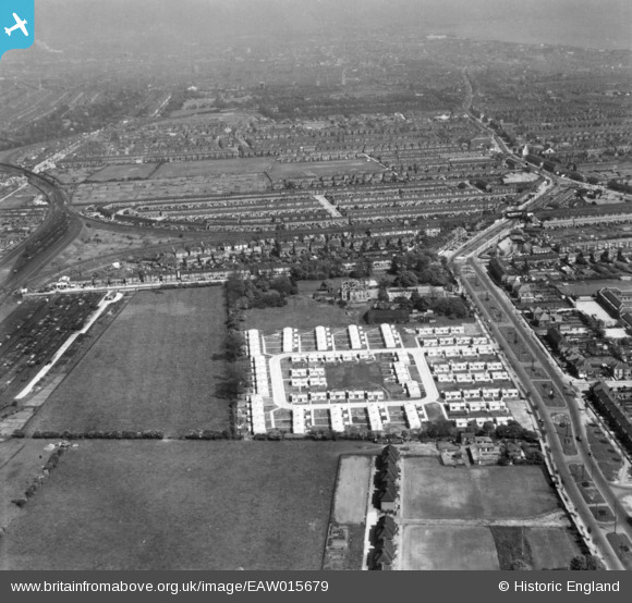
EAW015679 ENGLAND (1948). Pre-fabricated housing around Arcon Drive and environs, East Ella, from the west, 1948. This image has been produced from a print.
© Copyright OpenStreetMap contributors and licensed by the OpenStreetMap Foundation. 2026. Cartography is licensed as CC BY-SA.
Details
| Title | [EAW015679] Pre-fabricated housing around Arcon Drive and environs, East Ella, from the west, 1948. This image has been produced from a print. |
| Reference | EAW015679 |
| Date | 18-May-1948 |
| Link | |
| Place name | EAST ELLA |
| Parish | |
| District | |
| Country | ENGLAND |
| Easting / Northing | 505618, 428902 |
| Longitude / Latitude | -0.39826343427786, 53.745557277172 |
| National Grid Reference | TA056289 |
Pins

CartoonHead |
Saturday 12th of March 2016 03:20:19 PM | |
 |
CartoonHead |
Saturday 12th of March 2016 02:57:28 PM |
|
John Wass |
Friday 27th of February 2015 08:28:14 PM | |
|
John Wass |
Friday 27th of February 2015 08:23:09 PM | |
|
John Wass |
Friday 26th of December 2014 08:47:04 PM | |
|
John Wass |
Friday 21st of November 2014 08:34:56 PM | |
|
John Wass |
Friday 21st of November 2014 08:33:14 PM | |
|
John Wass |
Friday 21st of November 2014 08:31:45 PM | |
|
John Wass |
Friday 21st of November 2014 08:31:06 PM | |
Springbank North Signal Box |
James Wells |
Tuesday 28th of April 2026 05:07:29 AM |
|
CartoonHead |
Saturday 20th of September 2014 09:32:08 AM | |
Known locally as "Anlaby High Road". |
John Wass |
Friday 26th of December 2014 08:45:01 PM |
|
CartoonHead |
Saturday 20th of September 2014 09:31:13 AM | |
|
CartoonHead |
Saturday 20th of September 2014 09:30:35 AM |