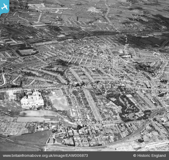
EAW006873 ENGLAND (1947). Okus and the town, Swindon, from the south, 1947
© Copyright OpenStreetMap contributors and licensed by the OpenStreetMap Foundation. 2025. Cartography is licensed as CC BY-SA.
Details
| Title | [EAW006873] Okus and the town, Swindon, from the south, 1947 |
| Reference | EAW006873 |
| Date | 10-June-1947 |
| Link | |
| Place name | SWINDON |
| Parish | |
| District | |
| Country | ENGLAND |
| Easting / Northing | 414923, 183448 |
| Longitude / Latitude | -1.7847578331808, 51.549247575834 |
| National Grid Reference | SU149834 |
Pins

Gary |
Friday 30th of August 2024 06:42:18 PM | |

Gary |
Friday 30th of August 2024 06:41:19 PM | |

Gary |
Friday 30th of August 2024 06:40:33 PM | |

Gary |
Friday 30th of August 2024 06:39:53 PM | |

Gary |
Friday 30th of August 2024 06:38:48 PM | |

Gary |
Friday 30th of August 2024 06:37:57 PM | |

Gary |
Friday 30th of August 2024 06:37:36 PM | |

Gary |
Friday 30th of August 2024 06:37:10 PM | |

Gary |
Friday 30th of August 2024 06:36:29 PM | |

Gary |
Friday 30th of August 2024 06:36:05 PM | |

NottmJas |
Saturday 16th of September 2023 10:05:27 PM | |

NottmJas |
Saturday 16th of September 2023 10:04:59 PM | |

NottmJas |
Saturday 16th of September 2023 10:02:36 PM | |

NottmJas |
Saturday 16th of September 2023 10:02:03 PM | |

NottmJas |
Saturday 16th of September 2023 10:00:57 PM | |

NottmJas |
Saturday 16th of September 2023 10:00:35 PM | |

NottmJas |
Saturday 16th of September 2023 09:59:33 PM | |

NottmJas |
Saturday 16th of September 2023 09:59:13 PM | |

zombieak |
Friday 10th of September 2021 07:56:01 PM | |

Post-war prefabs |
Monday 18th of November 2019 10:04:45 AM | |

Post-war prefabs |
Monday 18th of November 2019 10:03:20 AM | |

gBr |
Monday 11th of March 2019 10:07:29 PM | |

gBr |
Monday 11th of March 2019 10:06:43 PM | |

gBr |
Monday 11th of March 2019 10:05:16 PM | |

gBr |
Monday 11th of March 2019 10:03:23 PM | |

gBr |
Monday 11th of March 2019 10:01:12 PM | |

gBr |
Monday 11th of March 2019 09:59:42 PM | |

Class31 |
Wednesday 4th of March 2015 09:16:32 AM | |

gBr |
Wednesday 26th of November 2014 08:43:15 AM | |

Gerald Maull |
Sunday 3rd of August 2014 07:58:48 PM | |

Class31 |
Tuesday 14th of January 2014 10:21:21 AM | |

Class31 |
Tuesday 14th of January 2014 10:20:22 AM | |

Class31 |
Tuesday 14th of January 2014 10:19:54 AM | |

Class31 |
Tuesday 14th of January 2014 10:18:27 AM | |

Class31 |
Tuesday 14th of January 2014 10:18:03 AM |

