
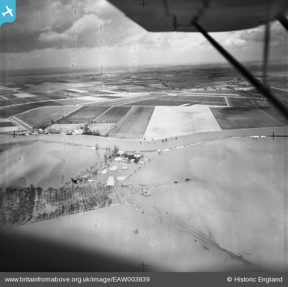
EAW003839 ENGLAND (1947). The River Great Ouse in flood at Queenholme Farm, Willingham, from the south-west, 1947
© Copyright OpenStreetMap contributors and licensed by the OpenStreetMap Foundation. 2026. Cartography is licensed as CC BY-SA.
Details
| Title | [EAW003839] The River Great Ouse in flood at Queenholme Farm, Willingham, from the south-west, 1947 |
| Reference | EAW003839 |
| Date | March-1947 |
| Link | |
| Place name | WILLINGHAM |
| Parish | WILLINGHAM |
| District | |
| Country | ENGLAND |
| Easting / Northing | 542820, 272197 |
| Longitude / Latitude | 0.096103219954418, 52.328863917356 |
| National Grid Reference | TL428722 |
Pins

Class31 |
Tuesday 17th of December 2013 08:59:18 AM | |
|
Class31 |
Tuesday 17th of December 2013 08:58:53 AM | |
|
Class31 |
Tuesday 17th of December 2013 08:56:14 AM | |
|
Class31 |
Tuesday 17th of December 2013 08:53:35 AM | |
|
Class31 |
Tuesday 17th of December 2013 08:52:40 AM | |
|
Class31 |
Tuesday 17th of December 2013 08:52:05 AM | |

melgibbs |
Sunday 1st of December 2013 11:04:09 AM | |

nkingdon |
Thursday 14th of November 2013 12:09:26 AM | |
Haddenham Engine(Pumping Station) |
Class31 |
Tuesday 17th of December 2013 08:51:25 AM |
User Comment Contributions
I had hoped to go through my thought processes as we hopefully identified a location. Well I just looked south of Ely and avoided the railway. I followed the River Great Ouse to Haddenham Engine Pumping Station which I believe is the location of this unlocated photograph. |
Class31 |
Tuesday 7th of January 2014 12:20:52 PM |
Thanks for spending time on this one Class31 - we'll update the catalogue and post the new data here in due course. Yours, Katy Britain from Above Cataloguing Team Leader |
Katy Whitaker |
Tuesday 7th of January 2014 12:20:52 PM |
View is looking north over the River Great Ouse. |
Class31 |
Tuesday 17th of December 2013 08:49:58 AM |
The plane is travelling north to south about half a mile east of Ely and has taken two photos EAW003837 and EAW003838 in relatively quick succession. The 64000$ question is whether the unlocated photo is going to be located a similar distance south of EAW003839 |
Class31 |
Tuesday 17th of December 2013 08:22:03 AM |
I have now had a look at EAW003837 which was taken of Flooding of the River Great Ouse at Middle Fen Bank, Ely, from the south-east, 1947. This photo was also taken in March 1947. In my view there is a high probablity that the series EAW003837 EAW003838 and EAW003839 were all taken on the same day , on the same flight and in sequence. |
Class31 |
Tuesday 17th of December 2013 08:16:55 AM |
I really think that we should be able to locate this picture. There is plenty of evidence here to enable an identification. I can not believe that it remains unidentified. Firstly we can look at the locations of the adjoining images. EAW003840 is of Anglesey Abbey, Lode taken on 5th April 1947. The other adjoining image is EAW003838 which is of Flooding of the River Great Ouse at Ely Dock Junction, Cawdle Fen, from the east, 1947 taken in March 1947. From this information I would deduce that there is a high probability that our unlocated image was taken near to the Cawdle Fen photograph. |
Class31 |
Tuesday 17th of December 2013 08:04:04 AM |
I have looked time and again but drawn a blank on this one. I guess it is somewhere in the Fens, but where? |
Class31 |
Saturday 21st of September 2013 04:03:20 PM |