© Copyright OpenStreetMap contributors and licensed by the OpenStreetMap Foundation. 2026. Cartography is licensed as CC BY-SA.
Details
| Title |
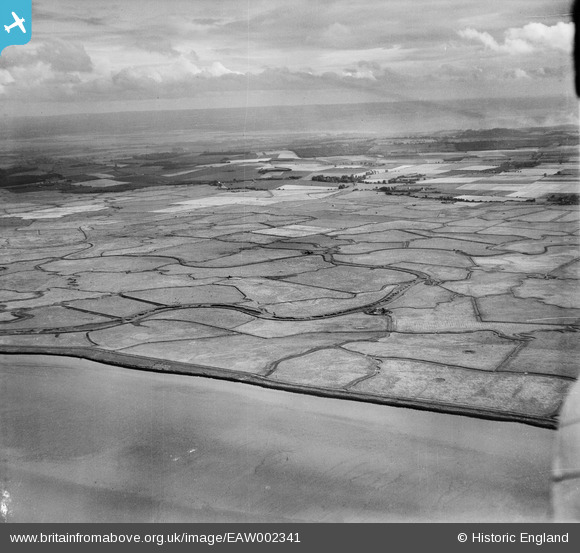
[EAW002341] Cliffe Marshes, Cliffe, from the north, 1946 |
| Reference |
EAW002341 |
| Date |
5-September-1946 |
| Link |
|
| Place name |
CLIFFE |
| Parish |
CLIFFE AND CLIFFE WOODS |
| District |
|
| Country |
ENGLAND |
| Easting / Northing |
574124, 178834 |
| Longitude / Latitude |
0.50791547263128, 51.481134028591 |
| National Grid Reference |
TQ741788 |
Pins
 Location of the gun pits for the 2ndWW HAA Gun Battery at Cooling, designation 13/-. (GDA Thames and Medway). |

redmist |
Monday 27th of July 2020 11:49:58 AM |
Faint vertical lines show the MUSA Antenna stretching across the marsh. Cooling Radio Station was at the UK end of a point-to-point, shortwave signal beamed from Lawrenceville, New Jersey. The site of the station was carefully selected as the antenna, MUSA (Multiple Unit Steerable Antenna), upon which it depended to receive the incoming transmission, had to be: directly aligned with Lawrenceville; two miles long; comprised of an array of 16 individual rhombic antenna; have an area of three miles in front of the MUSA that would be free from radio interference. The 16 rhombic antenna were strung between 60ft high telegraph poles; each side was 315ft long with internal angles of 140 degrees. The signal from each antenna was sent to the station via a core coaxial cable sheathed in a watertight copper tube and buried in a central trench.
See : English Heritage Research Department Report Series No 110-2010, ISSN 1749-8775, COOLING RADIO STATION, HOO PENINSULA, KENT - An Archaeological Investigation of a Short-Wave Receiving Station by Derwin Gregory and Sarah Newsome.
See also image EAW052580. |
Kentishman |
Saturday 27th of February 2016 01:48:10 PM |