Groups
Archaeological Sites and Monuments
About the group A group dedicated to early aerial archaeology. See the GROUP CHAT tab for more info!
Created 22 June 2012
|
Hello My name is Steve And I am looking for pre 1970s crop circle photographs. If you spot any could you let me know, thank you.
|

steve.pyrah |
|
|
Didn't think I'd see him on here.
|
Brian Wilkinson |
|
|
Very close to the circular feature in EPW038821, near Wennington Hall School, Lancashire. I can't see this on Google Maps (though the feature in EPW038821 is visible) and cannot find any reference.
|
David Parry |
|
|
Wennington, Lancashire. As added by Rebecca, now with the photo linked. I'm not sure of the extent of the grounds of Wennington Hall School, but this feature is probably within them.
|
David Parry |
|
|
It seems to be shown on the 6 inch First Edition OS map - only looking online at low resolution as I write, but there is a circle enclosing trees and possibly another symbol - will need to look at a clearer version of the map.
|
David Parry |
|
|
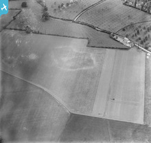
EPW038356 and EPW038355 (not sure how to link to the photos) are of some sort of archaeological crop/soil mark
|
Rebecca |
|
|
Hi Rebecca - when you come across a photo you want to add to a group, you will see a -select group- menu just below the image with a choice of locations to "Add to".
|
David Parry |
|
|
Possible archaeological crop marks on this as yet unlocated photo. Already put forward by "Rebecca", but without the image included.
|
David Parry |
|
|
A multivallate Iron Age hillfort, oval in plan, measuring 580 metres east-west by 460 metres north-south. The earthworks are well preserved and comprise two banks and a medial ditch with two entrances, one on the eastern side which is approached by a causeway and one on the west side which is thought to be medieval in origin.
http://bit.ly/O3m9dC |
Brian Wilkinson |
|

That's where I fly from. Have hundreds of images since 2006. We took off in deep snow in 2009 - here's an image.
|
Voyeur |
|
|
@Voyeur - that's a great image, and I bet on such a snowy day you were glad of an enclosed cockpit!
|
Brian Wilkinson |
|
|
While working for Wessex Archaeology several years ago, I excavated two sections through the Roman road between Silchester and Old Sarum, just beyond the roundabout on The Protway (top centre of this photo). Part of an evaluation (the backfilled trenches of which are still visible on the Google maps aerial view), we identified the remnants of the road makeup which had survived ploughing and a shallow depth of the roadside ditches.
|
David Parry |
|
|
EPW038822 is a nice barrow - walled kitchen garden in the background.
|
Rebecca |
|
|
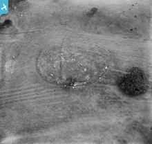
EPW038821 and EPW038823 are of the same site - some sort of circular earthwork bisected by another earthwork, with on one side ?ridge and furrow surrounding but respecting it.
|
Rebecca |
|
|
The site of a Neolithic ovoid causewayed enclosure on Bury Hill.
http://www.pastscape.org.uk/hob.aspx?hob_id=393256 |
BruceR |
|
|
Beeston Castle
now run by English Heritage. There are a couple of hills on the plain that command the whole area. Beeston Castle is on one and Peckforton Castle is on the other. http://goo.gl/rRfUT |
BruceR |
|
|
The Rickle and Cormorant Island in Linlithgow Loch are two artificial islands or Crannogs.
|
Brian Wilkinson |
|
|
Tredegar Fort has a roughly pentagonal inner enclosure approximately 142m from north-east to south-west by 70 to 112m, defined by a bank, ditch and counterscarp.
http://bit.ly/LaHJp2 |
Brian Wilkinson |
|
|
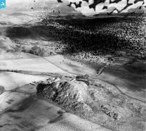
Dunadd: This Dark Age fortress stands on top of an isolated hill, once protected on nearly all sides by marshy ground. It is thought to have been the capital of the Scottish kingdom at Dalriada, founded by colonists from Ireland about A D 500.
http://bit.ly/Mo9IDC |
Brian Wilkinson |