
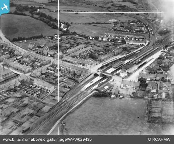
wpw029435 WALES (1929). View of Llantrisant station, Pontyclun, oblique aerial view. 5"x4" black and white glass plate negative.
© Copyright OpenStreetMap contributors and licensed by the OpenStreetMap Foundation. 2024. Cartography is licensed as CC BY-SA.
Nearby Images (4)
WPW029435

WPW029436

WPW029433

WPW029434

Details
| Title | [WPW029435] View of Llantrisant station, Pontyclun, oblique aerial view. 5"x4" black and white glass plate negative. |
| Reference | WPW029435 |
| Date | 1929 |
| Link | Coflein Archive Item 6378018 |
| Place name | |
| Parish | |
| District | |
| Country | WALES |
| Easting / Northing | 303573, 181440 |
| Longitude / Latitude | -3.3900514681363, 51.52315288357 |
| National Grid Reference | ST036814 |
Pins
 Ianto |
Wednesday 2nd of December 2015 11:41:17 AM |
User Comment Contributions
Yes, Llantrisant Station looking to the west.Cowbridge Road is to the left and leads on to Brynsadler.Top right is River Row.The field in the forefront is now Pontyclun Rugby Club and field.Many of the allotments on the left were given up for house building. |
EDGELEY THOMAS |
Friday 29th of June 2012 10:26:59 PM |
Website will not allow users to provide the map reference. |
 Class31 |
Wednesday 27th of June 2012 02:41:56 PM |
 Llantrisant Station now reopened as Pontyclun Station. Image previously unidentified. |
Class31 |
Wednesday 27th of June 2012 11:26:15 AM |
Llantrisant Station now reopened as Pontyclun Station. Previously unlocated. |
Class31 |
Tuesday 26th of June 2012 10:31:31 PM |
Llantrisant Station Great Western Railway looking West. Railway line to Cowbridge curves away to the left. |
Class31 |
Tuesday 26th of June 2012 12:33:24 PM |


