
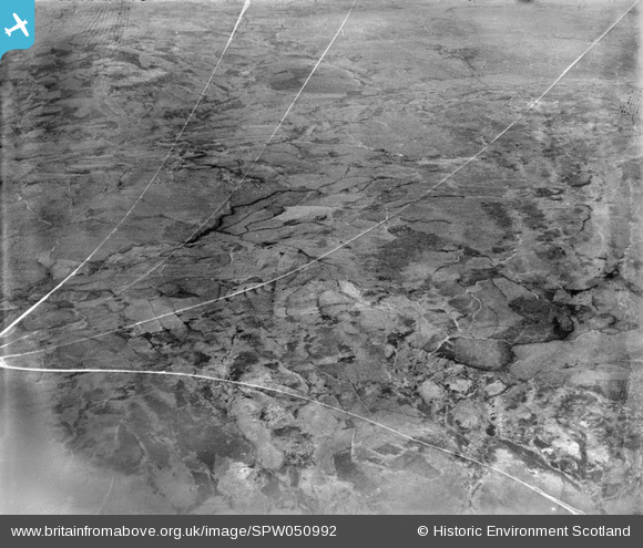
spw050992 SCOTLAND (1936). Glenapp Estate. An oblique aerial photograph facing east.
© Copyright OpenStreetMap contributors and licensed by the OpenStreetMap Foundation. 2024. Cartography is licensed as CC BY-SA.
Nearby Images (5)
SPW050978

SPW050980

SPW050992

SPW050999

SPW051001

Details
| Title | [SPW050992] Glenapp Estate. An oblique aerial photograph facing east. |
| Reference | SPW050992 |
| Date | 1936 |
| Link | Canmore Collection item 1258058 |
| Place name | |
| Parish | BALLANTRAE (KYLE AND CARRICK) |
| District | KYLE AND CARRICK |
| Country | SCOTLAND |
| Easting / Northing | 208000, 573000 |
| Longitude / Latitude | -5.0033093572422, 55.014361946464 |
| National Grid Reference | NX080730 |
Pins
 Class31 |
Monday 23rd of July 2012 02:00:58 PM | |
Class31 |
Monday 23rd of July 2012 01:12:31 PM | |
Class31 |
Monday 23rd of July 2012 01:11:00 PM | |
Class31 |
Monday 23rd of July 2012 01:09:49 PM | |
Class31 |
Monday 23rd of July 2012 01:08:30 PM | |
Class31 |
Monday 23rd of July 2012 01:04:46 PM |
User Comment Contributions
Dear Class 31, Having now seen and verified SPW050999 I can now see the March Burn and the 'Batenburg cake' pattern of vegetation cover on Drumcargo clearly on this image, making the validation of this location much easier. The revised record will appear here in due course. Brian Wilkinson Britain from Above Activity Officer (Scotland) |
 Brian Wilkinson |
Friday 31st of August 2012 03:11:47 PM |
Another photo with not many line features. Not many identifiable features at all! Looking East from above Tammock Burn towards Drumcargo. March Burn helps to identify the view.Mid Moile is to the right and Wee Leith Hill is in the middle right. I don't think there is a road anywhere in this view. |
Class31 |
Monday 23rd of July 2012 02:06:44 PM |


