
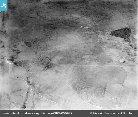
spw050982 SCOTLAND (1936). Glenapp Estate. An oblique aerial photograph facing east.
© Copyright OpenStreetMap contributors and licensed by the OpenStreetMap Foundation. 2024. Cartography is licensed as CC BY-SA.
Details
| Title | [SPW050982] Glenapp Estate. An oblique aerial photograph facing east. |
| Reference | SPW050982 |
| Date | 1936 |
| Link | Canmore Collection item 1258049 |
| Place name | |
| Parish | INCH |
| District | WIGTOWN |
| Country | SCOTLAND |
| Easting / Northing | 206850, 570120 |
| Longitude / Latitude | -5.0193266836554, 54.988069763473 |
| National Grid Reference | NX069701 |
Pins
 Class31 |
Thursday 19th of July 2012 10:28:09 PM | |
Class31 |
Thursday 19th of July 2012 09:46:26 PM | |
Class31 |
Thursday 19th of July 2012 09:44:17 PM | |
Class31 |
Thursday 19th of July 2012 09:43:16 PM | |
Class31 |
Thursday 19th of July 2012 09:41:08 PM | |
Class31 |
Thursday 19th of July 2012 09:40:28 PM | |
Class31 |
Thursday 19th of July 2012 09:39:13 PM |
User Comment Contributions
Dear Class 31, I believe your confidence is well placed! The layout of this field system is still visible on the current OS 1:10000, and corresponds very well with the 1st Edition Ordnance Survey (which can be viewed online at http://maps.nls.uk/os/6inch/index.html). It is interesting that the large field in centre frame is marked as "Heathy Pasture" on the 1st ed OS, with several hay rees marked to its W. At least one of rees appears to have been converted to a sheepfold by the time this photograph was taken, which might suggest something about the changing farm economy of the estate. The revised record will appear here in due course. Brian Wilkinson Britain from Above Activity Officer (Scotland) |
 Brian Wilkinson |
Thursday 30th of August 2012 01:12:15 PM |
The Taxing Stone, is according to Link believed to be a Toll point and standing stone which marks the burial-place of Alpin, King of Dalriada, killed in 741 in Glenapp. |
Class31 |
Thursday 19th of July 2012 10:30:23 PM |
View looking East over Laird's Hill with Little Laight Farmhouse on the left and Meikle Laight on the right. Highfall Wood is further over with Duckdubs Burn in the distance. On present day maps there is a reservoir just below Highfall Wood. I can only hope that this was built since 1936. The field patterns are right. I am confident on this one. |
Class31 |
Thursday 19th of July 2012 09:54:55 PM |


