
spw020631 SCOTLAND (1928). Fannyside Nature Reserve. An oblique aerial photograph.

© Copyright OpenStreetMap contributors and licensed by the OpenStreetMap Foundation. 2024. Cartography is licensed as CC BY-SA.
Details
| Title | [SPW020631] Fannyside Nature Reserve. An oblique aerial photograph. |
| Reference | SPW020631 |
| Date | 1928 |
| Link | Canmore Collection item 1256389 |
| Place name | |
| Parish | SLAMANNAN |
| District | FALKIRK |
| Country | SCOTLAND |
| Easting / Northing | 281260, 673310 |
| Longitude / Latitude | -3.9011482121699, 55.938194760561 |
| National Grid Reference | NS813733 |
Pins
 Class31 |
Monday 16th of July 2012 11:14:48 AM | |
Class31 |
Monday 16th of July 2012 11:08:03 AM | |
Class31 |
Monday 16th of July 2012 11:00:00 AM | |
Class31 |
Monday 16th of July 2012 10:57:18 AM | |
Class31 |
Monday 16th of July 2012 10:56:53 AM | |
Class31 |
Monday 16th of July 2012 10:55:47 AM | |
Class31 |
Monday 16th of July 2012 10:54:50 AM |
User Comment Contributions
Dear all, we've reviewed your comments and thanks to your hep we can now update the catalogue. I have checked with modern aerial photography, Google Earth, the current 1:1000 OS maps and historic mapping, and can confirm your observations. Interestingly the 1st Edition OS map (1864) labels the area as 'Liable to Floods', hence perhaps the extensive drainage ditches we can see in the photo. Brian Wilkinson Britain from Above Activity Officer (Scotland) |
 Brian Wilkinson |
Thursday 30th of August 2012 10:19:26 AM |
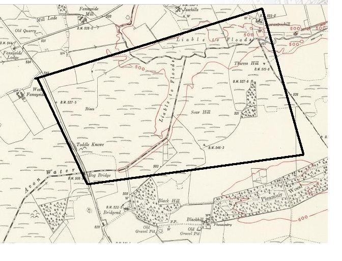 I agree with Class31 bends in river/streams/ditches and the woodland match up with map see http://maps.nls.uk/os/6inch-2nd-and-later/view/?sid=75827525 |
slowcoach |
Tuesday 17th of July 2012 10:01:51 PM |
Thanks for the confirmation. |
Class31 |
Tuesday 17th of July 2012 10:01:51 PM |
I think that I can identify this image as the Fannyside Nature Reserve looking East. All the features seem to fit. The road at the bottom of the picture. The river going away from us at the top of the picture becoming the River Avon. The bends in the river fit with the Fannyside location. The two hills Thieves Hill and Star hill seem to be in the right places.There is a straight drainage ditch in the right place. It all appears to make the whole. The image is in the right place as the previous one was at Castlecary very close by. |
Class31 |
Monday 16th of July 2012 11:14:05 AM |


