
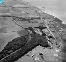
saw009796 SCOTLAND (1947). Turnberry, general view, showing Turnberry Hotel and Maidens Road. An oblique aerial photograph taken facing south.

© Copyright OpenStreetMap contributors and licensed by the OpenStreetMap Foundation. 2024. Cartography is licensed as CC BY-SA.
Nearby Images (15)
SAR016573

SAR019254

SAW009796

SPW034355

SPW034356

SPW034357

SPW034359

SPW034360

SPW034361

SPW034363

SPW034364

SPW034365

SPW051063

SPW034358

SPW034362

Details
| Title | [SAW009796] Turnberry, general view, showing Turnberry Hotel and Maidens Road. An oblique aerial photograph taken facing south. |
| Reference | SAW009796 |
| Date | 1947 |
| Link | Canmore Collection item 1268641 |
| Place name | |
| Parish | KIRKOSWALD |
| District | KYLE AND CARRICK |
| Country | SCOTLAND |
| Easting / Northing | 220571, 605863 |
| Longitude / Latitude | -4.8277580390401, 55.314035028424 |
| National Grid Reference | NS206059 |
Pins
 Al |
Monday 19th of January 2015 11:53:36 AM | |
Graham Yaxley |
Sunday 18th of January 2015 11:24:04 PM |
User Comment Contributions
 25yd firing range |
Al |
Monday 19th of January 2015 12:29:50 PM |


