
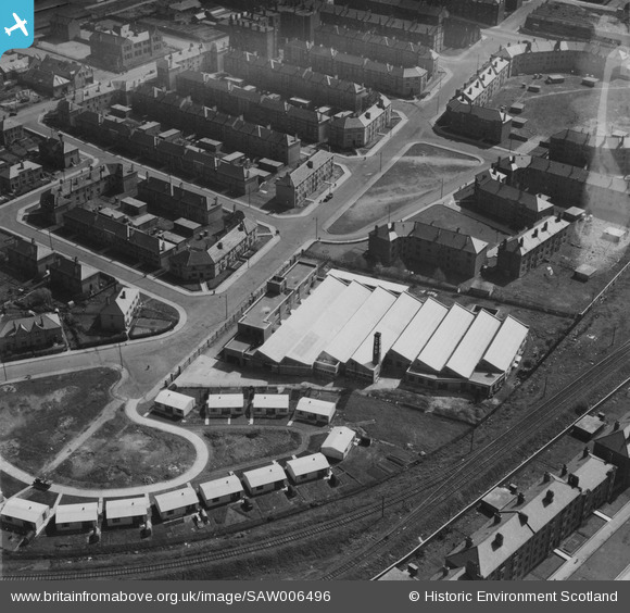
saw006496 SCOTLAND (1947). Farquharson Brothers Ltd. Cyro Works, Sutcliffe Road, Glasgow. An oblique aerial photograph taken facing east. This image has been produced from a damaged print.
© Copyright OpenStreetMap contributors and licensed by the OpenStreetMap Foundation. 2024. Cartography is licensed as CC BY-SA.
Nearby Images (7)
SAW006496

SAW006497

SAW006498

SAW006499

SAW006500

SAW006501

SAW006502

Details
| Title | [SAW006496] Farquharson Brothers Ltd. Cyro Works, Sutcliffe Road, Glasgow. An oblique aerial photograph taken facing east. This image has been produced from a damaged print. |
| Reference | SAW006496 |
| Date | 1947 |
| Link | Canmore Collection item 1314694 |
| Place name | |
| Parish | NEW KILPATRICK (CITY OF GLASGOW) |
| District | CITY OF GLASGOW |
| Country | SCOTLAND |
| Easting / Northing | 254404, 669153 |
| Longitude / Latitude | -4.3285379062867, 55.89349014504 |
| National Grid Reference | NS544692 |
Pins
 redmist |
Wednesday 13th of January 2021 10:05:17 PM | |
redmist |
Wednesday 13th of January 2021 10:04:55 PM | |
redmist |
Wednesday 13th of January 2021 10:04:27 PM | |
redmist |
Wednesday 13th of January 2021 10:04:02 PM | |
redmist |
Wednesday 13th of January 2021 10:03:35 PM | |
redmist |
Wednesday 13th of January 2021 10:03:10 PM |
User Comment Contributions
looks like prefabricated housing with Anderson shelters reused as sheds, certainly the Anderson shelter would normally have been erected in a trench and the spoil used to cover the roof to provide protection against bomb splinters |
Al |
Thursday 23rd of October 2014 01:21:20 PM |


