
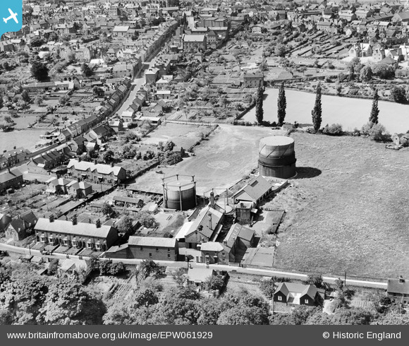
epw061929 ENGLAND (1939). Ludlow Union Gas Co Works, Ludlow, 1939
© Copyright OpenStreetMap contributors and licensed by the OpenStreetMap Foundation. 2024. Cartography is licensed as CC BY-SA.
Nearby Images (6)
EPW061929

EPW061711

EPW061712

EPW061710

EPW061709

EPW061923

Details
| Title | [EPW061929] Ludlow Union Gas Co Works, Ludlow, 1939 |
| Reference | EPW061929 |
| Date | 6-June-1939 |
| Link | |
| Place name | LUDLOW |
| Parish | LUDLOW |
| District | |
| Country | ENGLAND |
| Easting / Northing | 351526, 274375 |
| Longitude / Latitude | -2.7119737675107, 52.364898304697 |
| National Grid Reference | SO515744 |
Pins
 totoro |
Tuesday 17th of September 2013 06:32:39 PM | |
totoro |
Tuesday 17th of September 2013 06:32:12 PM | |
totoro |
Tuesday 17th of September 2013 06:31:27 PM | |
totoro |
Tuesday 17th of September 2013 06:30:30 PM | |
totoro |
Tuesday 17th of September 2013 06:29:56 PM | |
totoro |
Tuesday 17th of September 2013 06:27:37 PM | |
totoro |
Tuesday 17th of September 2013 06:21:58 PM | |
totoro |
Tuesday 17th of September 2013 06:20:05 PM | |
totoro |
Tuesday 17th of September 2013 06:18:34 PM | |
totoro |
Tuesday 17th of September 2013 06:18:15 PM | |
totoro |
Tuesday 17th of September 2013 06:17:55 PM |


