
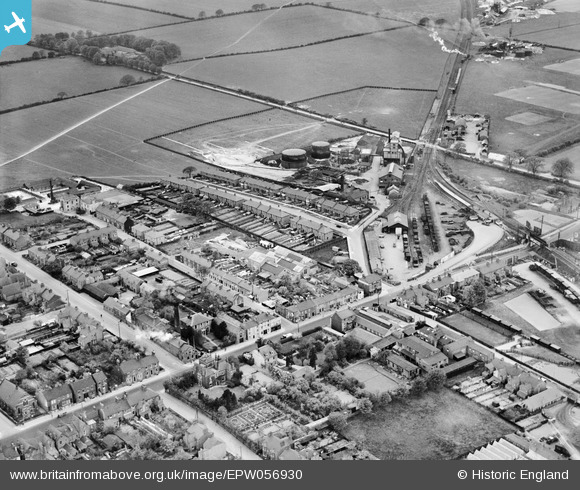
epw056930 ENGLAND (1938). Dunstable North Railway Station and environs, Dunstable, 1938
© Copyright OpenStreetMap contributors and licensed by the OpenStreetMap Foundation. 2024. Cartography is licensed as CC BY-SA.
Details
| Title | [EPW056930] Dunstable North Railway Station and environs, Dunstable, 1938 |
| Reference | EPW056930 |
| Date | 26-April-1938 |
| Link | |
| Place name | DUNSTABLE |
| Parish | DUNSTABLE |
| District | |
| Country | ENGLAND |
| Easting / Northing | 501176, 222489 |
| Longitude / Latitude | -0.52959514225898, 51.89132162132 |
| National Grid Reference | TL012225 |
Pins
 nansue |
Saturday 16th of January 2016 04:26:11 PM | |
alastair wallace |
Sunday 20th of December 2015 10:09:23 PM | |
nansue |
Saturday 18th of April 2015 09:57:47 AM | |
nansue |
Thursday 27th of February 2014 02:31:18 PM | |
nansue |
Thursday 27th of February 2014 02:30:03 PM | |
maltabazzz |
Thursday 9th of January 2014 07:27:35 PM | |
maltabazzz |
Thursday 9th of January 2014 07:14:35 PM | |
maltabazzz |
Thursday 9th of January 2014 07:13:10 PM | |
nansue |
Sunday 8th of December 2013 03:38:20 PM | |
nansue |
Sunday 8th of December 2013 03:33:29 PM | |
nansue |
Sunday 8th of December 2013 03:29:20 PM | |
nansue |
Sunday 8th of December 2013 12:03:37 PM | |
Big G |
Wednesday 9th of October 2013 03:24:54 PM | |
Big G |
Wednesday 9th of October 2013 12:27:39 PM | |
Big G |
Wednesday 9th of October 2013 12:26:00 PM | |
MB |
Sunday 18th of August 2013 11:22:00 PM | |
MB |
Sunday 18th of August 2013 11:21:02 PM | |
MB |
Sunday 18th of August 2013 11:19:43 PM | |
MB |
Sunday 18th of August 2013 11:19:02 PM | |
MB |
Sunday 18th of August 2013 11:16:34 PM | |
MB |
Sunday 18th of August 2013 11:14:40 PM | |
MB |
Sunday 18th of August 2013 11:09:17 PM | |
MB |
Sunday 18th of August 2013 11:08:49 PM | |
MB |
Sunday 18th of August 2013 11:07:42 PM | |
MB |
Sunday 18th of August 2013 11:06:35 PM | |
ordinarybloke |
Sunday 18th of August 2013 03:14:47 PM | |
Westfield Road it is - built after 1924 |
MB |
Sunday 18th of August 2013 11:14:07 PM |
Hi YES this is Westfield Rd |
maltabazzz |
Thursday 9th of January 2014 07:33:58 PM |
ordinarybloke |
Sunday 18th of August 2013 03:13:13 PM | |
ordinarybloke |
Sunday 18th of August 2013 03:08:09 PM | |
ordinarybloke |
Sunday 18th of August 2013 03:07:26 PM | |
ordinarybloke |
Sunday 18th of August 2013 03:03:58 PM | |
ordinarybloke |
Sunday 18th of August 2013 02:57:01 PM | |
 Dylan Moore |
Saturday 15th of June 2013 03:21:30 PM |
User Comment Contributions
Looking west south west, roughly |
MB |
Sunday 18th of August 2013 11:11:40 PM |


