
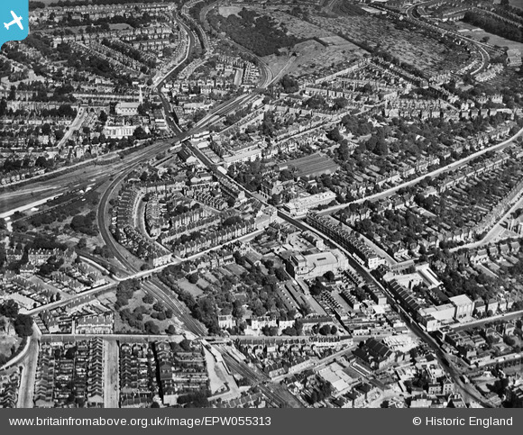
epw055313 ENGLAND (1937). Norwood Road and environs, Streatham, 1937
© Copyright OpenStreetMap contributors and licensed by the OpenStreetMap Foundation. 2024. Cartography is licensed as CC BY-SA.
Nearby Images (2)
EPW055313

EAW029154

Details
| Title | [EPW055313] Norwood Road and environs, Streatham, 1937 |
| Reference | EPW055313 |
| Date | September-1937 |
| Link | |
| Place name | STREATHAM |
| Parish | |
| District | |
| Country | ENGLAND |
| Easting / Northing | 531803, 172559 |
| Longitude / Latitude | -0.1035579910482, 51.436185513763 |
| National Grid Reference | TQ318726 |
Pins
 stevewelburn |
Saturday 12th of September 2020 09:45:28 AM | |
stevewelburn |
Saturday 12th of September 2020 09:43:38 AM | |
stevewelburn |
Saturday 12th of September 2020 09:38:19 AM | |
brianbeckett |
Sunday 29th of March 2020 09:42:27 PM | |
brianbeckett |
Friday 9th of February 2018 02:41:34 PM | |
John Wass |
Friday 26th of June 2015 03:47:56 PM | |
John Wass |
Friday 26th of June 2015 03:46:54 PM | |
John Wass |
Friday 26th of June 2015 03:45:37 PM | |
John Wass |
Friday 26th of June 2015 03:45:12 PM | |
Paul Noel |
Monday 24th of November 2014 04:15:03 PM | |
brianbeckett |
Wednesday 17th of September 2014 02:36:51 PM | |
Paul Noel |
Monday 30th of June 2014 04:50:56 PM | |
Paul Noel |
Monday 30th of June 2014 04:49:18 PM | |
Paul Noel |
Monday 30th of June 2014 04:48:12 PM | |
Paul Noel |
Monday 30th of June 2014 04:47:13 PM | |
Chris Willis |
Tuesday 11th of June 2013 05:15:14 PM | |
Chris Willis |
Tuesday 11th of June 2013 05:10:06 PM | |
St. Cuthberts - now a school |
Paul Noel |
Monday 30th of June 2014 07:29:10 PM |
Chris Willis |
Tuesday 11th of June 2013 05:05:35 PM | |
Chris Willis |
Tuesday 11th of June 2013 04:38:19 PM | |
Chris Willis |
Tuesday 11th of June 2013 04:37:21 PM | |
Chris Willis |
Tuesday 11th of June 2013 04:36:36 PM | |
Chris Willis |
Tuesday 11th of June 2013 04:36:06 PM | |
Chris Willis |
Tuesday 11th of June 2013 04:32:11 PM | |
Chris Willis |
Tuesday 11th of June 2013 04:31:46 PM | |
Chris Willis |
Tuesday 11th of June 2013 04:31:06 PM | |
Chris Willis |
Tuesday 11th of June 2013 04:23:10 PM | |
Chris Willis |
Tuesday 11th of June 2013 04:08:27 PM | |
Not really. The line through Knight's Hill tunnel belonged to the London, Brighton & South Coast railway company. The one curved around the high ground was built by the South East & Chatham railway company. They were bitter rivals and in any case, as the railway emerged from the tunnel at the other end the track level was too high for a connection to Herne Hill which is where the S.E.C.R. was going. |
John Wass |
Tuesday 14th of April 2015 03:40:56 PM |
User Comment Contributions
Hi Chris, Thanks for all the pins to help with this image. We'll update the catalogue and post the new record here in due course. Yours, Katy Britain from Above Cataloguing Team Leader |
Katy Whitaker |
Tuesday 2nd of July 2013 05:12:44 PM |


