
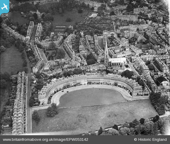
epw053142 ENGLAND (1937). The Royal Crescent, St Andrew's Church and St James's Square, Bath, 1937
© Copyright OpenStreetMap contributors and licensed by the OpenStreetMap Foundation. 2024. Cartography is licensed as CC BY-SA.
Nearby Images (11)
EPW053142

EAW027311

EPW048395

EPW048394

EAW026453

EPW001940

EPW001949

EAW026454

EAW049895

EAW026452

EPW033155

Details
| Title | [EPW053142] The Royal Crescent, St Andrew's Church and St James's Square, Bath, 1937 |
| Reference | EPW053142 |
| Date | 19-May-1937 |
| Link | |
| Place name | BATH |
| Parish | |
| District | |
| Country | ENGLAND |
| Easting / Northing | 374509, 165502 |
| Longitude / Latitude | -2.3663724870939, 51.387491901505 |
| National Grid Reference | ST745655 |
Pins
 H Campbell |
Wednesday 11th of February 2015 09:39:35 PM | |
H Campbell |
Wednesday 11th of February 2015 09:33:38 PM | |
H Campbell |
Wednesday 11th of February 2015 09:30:31 PM | |
H Campbell |
Wednesday 11th of February 2015 09:28:30 PM | |
H Campbell |
Wednesday 11th of February 2015 09:27:24 PM | |
cvb |
Wednesday 8th of October 2014 04:27:54 PM | |
 Class31 |
Saturday 22nd of June 2013 03:00:32 PM | |
Class31 |
Saturday 22nd of June 2013 02:59:52 PM | |
Class31 |
Saturday 22nd of June 2013 02:59:11 PM | |
Class31 |
Saturday 22nd of June 2013 02:58:10 PM |


