
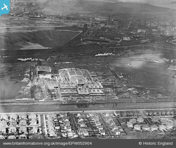
epw052904 ENGLAND (1937). The Mersey Works (Paper Board) under construction and environs, Warrington, 1937
© Copyright OpenStreetMap contributors and licensed by the OpenStreetMap Foundation. 2024. Cartography is licensed as CC BY-SA.
Nearby Images (19)
EPW052904
 under construction and environs, Warrington, 1937")
EPW055703
, Warrington, 1937")
EPW055702
, Warrington, 1937")
EPW055704
, Warrington, 1937")
EPW055701
, Warrington, 1937")
EPW052906
 under construction and environs, Warrington, 1937")
EPW055698
, Warrington, 1937")
EPW055699
, Warrington, 1937")
EPW053326
 under construction, Warrington, 1937")
EPW052902
 under construction and environs, Warrington, 1937")
EPW053324
 under construction, Warrington, 1937")
EPW053327
 under construction, Warrington, 1937")
EPW053329
 under construction, Warrington, 1937")
EPW053328
 under construction, Warrington, 1937")
EPW053325
 under construction, Warrington, 1937")
EPW055700
 and environs, Warrington, 1937")
EPW052905
 under construction and environs, Warrington, 1937")
EPW052901
 under construction and environs, Warrington, 1937")
EPW052903
 under construction and environs, Warrington, 1937")
Details
| Title | [EPW052904] The Mersey Works (Paper Board) under construction and environs, Warrington, 1937 |
| Reference | EPW052904 |
| Date | 24-April-1937 |
| Link | |
| Place name | WARRINGTON |
| Parish | |
| District | |
| Country | ENGLAND |
| Easting / Northing | 360316, 387268 |
| Longitude / Latitude | -2.5966431405616, 53.380506132249 |
| National Grid Reference | SJ603873 |
Pins
Be the first to add a comment to this image!


