
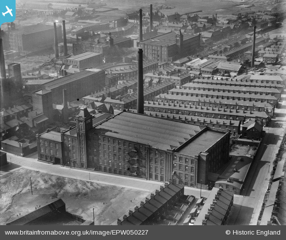
epw050227 ENGLAND (1936). Coldhurst Hall Cotton Mill and environs, Oldham, 1936
© Copyright OpenStreetMap contributors and licensed by the OpenStreetMap Foundation. 2024. Cartography is licensed as CC BY-SA.
Nearby Images (20)
EPW050227

EPW050228

EPW050225

EPW050224

EAW004280

EPW050226

EPW050229

EAW004277

EAW004276

EAW004281

EAW004279

EAW004278

EAW004431

EAW004430

EAW004432

EAW004434

EAW004435

EAW004433

EAW004429

EAW004436

Details
| Title | [EPW050227] Coldhurst Hall Cotton Mill and environs, Oldham, 1936 |
| Reference | EPW050227 |
| Date | May-1936 |
| Link | |
| Place name | OLDHAM |
| Parish | |
| District | |
| Country | ENGLAND |
| Easting / Northing | 392222, 405931 |
| Longitude / Latitude | -2.117406443909, 53.549710641058 |
| National Grid Reference | SD922059 |
Pins
 TheBlueCube |
Monday 17th of November 2014 02:34:18 AM | |
eddief |
Friday 20th of September 2013 07:14:12 PM | |
eddief |
Friday 20th of September 2013 07:05:26 PM | |
eddief |
Friday 20th of September 2013 07:03:49 PM | |
eddief |
Friday 20th of September 2013 07:02:18 PM | |
eddief |
Friday 20th of September 2013 06:56:09 PM | |
eddief |
Friday 20th of September 2013 06:53:44 PM | |
eddief |
Friday 20th of September 2013 06:52:45 PM | |
eddief |
Friday 20th of September 2013 06:52:14 PM | |
eddief |
Friday 20th of September 2013 05:56:16 PM |


