
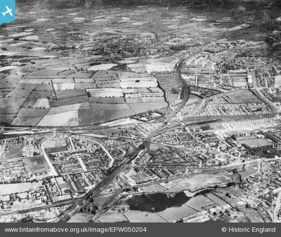
epw050204 ENGLAND (1936). Old Basford, Nottingham, from the south-west, 1936. This image has been produced from a copy-negative.
© Copyright OpenStreetMap contributors and licensed by the OpenStreetMap Foundation. 2024. Cartography is licensed as CC BY-SA.
Nearby Images (3)
EPW050204

EPW050208

EPW050210

Details
| Title | [EPW050204] Old Basford, Nottingham, from the south-west, 1936. This image has been produced from a copy-negative. |
| Reference | EPW050204 |
| Date | May-1936 |
| Link | |
| Place name | OLD BASFORD |
| Parish | |
| District | |
| Country | ENGLAND |
| Easting / Northing | 455694, 344207 |
| Longitude / Latitude | -1.1701791303791, 52.991985986462 |
| National Grid Reference | SK557442 |
Pins
 martynrb |
Thursday 26th of October 2023 12:40:29 PM | |
martynrb |
Thursday 26th of October 2023 12:39:27 PM | |
peter photo |
Wednesday 23rd of August 2023 04:33:40 PM | |
peter photo |
Wednesday 23rd of August 2023 04:33:31 PM | |
peter photo |
Wednesday 23rd of August 2023 04:32:17 PM | |
peter photo |
Wednesday 23rd of August 2023 04:32:13 PM | |
peter photo |
Wednesday 23rd of August 2023 04:30:19 PM | |
Moorponder |
Monday 9th of September 2019 03:43:06 PM | |
Moorponder |
Monday 9th of September 2019 03:42:18 PM | |
Moorponder |
Monday 9th of September 2019 03:34:48 PM | |
 Class31 |
Wednesday 29th of October 2014 10:11:59 AM | |
Class31 |
Wednesday 29th of October 2014 10:09:53 AM | |
Class31 |
Wednesday 29th of October 2014 10:08:04 AM | |
Class31 |
Wednesday 29th of October 2014 10:06:01 AM | |
Class31 |
Wednesday 29th of October 2014 10:00:40 AM | |
Class31 |
Wednesday 29th of October 2014 09:59:37 AM | |
Class31 |
Wednesday 29th of October 2014 09:56:36 AM | |
Class31 |
Wednesday 29th of October 2014 09:54:48 AM | |
Class31 |
Wednesday 29th of October 2014 09:53:06 AM | |
Class31 |
Wednesday 29th of October 2014 09:51:07 AM |

User Comment Contributions
Viewed from the south west. |
Class31 |
Wednesday 29th of October 2014 10:23:27 AM |
I have put the marker at the junction of Hucknall Road and Arnold Road near Old Basford. I was able to locate this one from the location of the adjoiningly numbered photo which covered the same area. However I located about ten pins on the old maps before I could find out where I was on the latest Ordnance Survey map. As it happens I was in Bulwell in August to buy a new hard drive when my old one packed up from overuse on Britain from Above. Fortunately I had saved most of my data. |
Class31 |
Wednesday 29th of October 2014 10:21:58 AM |
For information Bulwell is out of photo to the left. |
Class31 |
Wednesday 29th of October 2014 10:21:58 AM |
Much of the area is covered by the image EPW050203 which is of New housing estates and adjacent countryside, Old Basford, from the south-west, 1936 |
Class31 |
Wednesday 29th of October 2014 09:34:46 AM |


