
epw041650 ENGLAND (1933). New housing estate under construction between Altrincham Road and Royal Oak Road, Baguley, 1933

© Copyright OpenStreetMap contributors and licensed by the OpenStreetMap Foundation. 2024. Cartography is licensed as CC BY-SA.
Details
| Title | [EPW041650] New housing estate under construction between Altrincham Road and Royal Oak Road, Baguley, 1933 |
| Reference | EPW041650 |
| Date | June-1933 |
| Link | |
| Place name | BAGULEY |
| Parish | |
| District | |
| Country | ENGLAND |
| Easting / Northing | 381219, 389301 |
| Longitude / Latitude | -2.2824970817795, 53.399938742286 |
| National Grid Reference | SJ812893 |
Pins
 Stewbow |
Monday 18th of November 2019 04:54:55 PM | |
John Ellis |
Saturday 18th of January 2014 01:03:47 PM | |
John Ellis |
Saturday 18th of January 2014 01:03:04 PM | |
John Ellis |
Thursday 2nd of January 2014 07:00:50 PM | |
John Ellis |
Friday 27th of December 2013 02:24:44 PM | |
John Ellis |
Wednesday 25th of December 2013 12:02:04 AM | |
John Ellis |
Wednesday 25th of December 2013 12:00:13 AM | |
John Ellis |
Tuesday 24th of December 2013 11:58:57 PM | |
John Ellis |
Tuesday 24th of December 2013 11:56:29 PM | |
John Ellis |
Tuesday 24th of December 2013 11:54:27 PM | |
John Ellis |
Tuesday 24th of December 2013 11:51:51 PM | |
John Ellis |
Tuesday 24th of December 2013 11:51:15 PM | |
John Ellis |
Tuesday 24th of December 2013 11:50:24 PM | |
John Ellis |
Tuesday 24th of December 2013 11:47:35 PM | |
John Ellis |
Tuesday 24th of December 2013 11:46:32 PM | |
John Ellis |
Tuesday 24th of December 2013 11:45:28 PM | |
John Ellis |
Tuesday 24th of December 2013 11:44:42 PM | |
Recently passing this way for the first time in quite a while, I noticed that the old congregational church now seems to have vanished, along with the nearby last remaining traces of the former junction of Floats Road with Altrincham Road. |
John Ellis |
Tuesday 14th of January 2014 03:23:49 PM |
John Ellis |
Tuesday 24th of December 2013 11:43:24 PM | |
John Ellis |
Tuesday 24th of December 2013 11:42:02 PM | |
That's not Spark Rd, that's Westage Gardens! |
Jason |
Sunday 11th of May 2014 03:18:50 PM |
It's interesting to see that only half of Westage Gardens has been built, no trees or privet hedges too right throughout the whole construction site, and there are just road layouts and footings between Westage Gardens and Spark Rd, or rather the land that once lay behind the Royal Oak pub. |
Jason |
Sunday 11th of May 2014 09:25:57 PM |
John Ellis |
Tuesday 24th of December 2013 11:41:25 PM | |
John Ellis |
Tuesday 24th of December 2013 11:40:48 PM | |
John Ellis |
Tuesday 24th of December 2013 11:40:07 PM | |
John Ellis |
Tuesday 24th of December 2013 11:38:38 PM | |
John Ellis |
Tuesday 24th of December 2013 11:37:50 PM | |
John Ellis |
Tuesday 24th of December 2013 11:37:28 PM | |
John Ellis |
Tuesday 24th of December 2013 11:36:48 PM | |
John Ellis |
Tuesday 24th of December 2013 11:34:46 PM | |
John Ellis |
Tuesday 24th of December 2013 11:34:19 PM | |
John Ellis |
Tuesday 24th of December 2013 11:33:24 PM | |
John Ellis |
Tuesday 24th of December 2013 11:32:27 PM |
User Comment Contributions
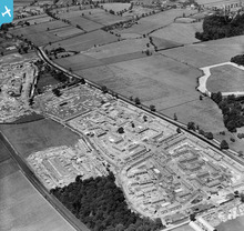 Manchester City Council acquired the estate of Wythenshawe Hall (which stands just beyond the top right-hand corner of this photograph) in 1926. The intention was to develop this almost completely rural area south of the Mersey - one of a very few open agricultural areas still remaining close to the city boundary - with public housing to enable slum clearance around the city centre. The local Bucklow Rural District Council having experienced difficulty in providing public services for the first stages of the new housing development, Manchester City Council was able in 1931 to engineer the transference of the three civil parishes of Northenden, Northen Etchells and Baguley from Bucklow Rural District and Cheshire County into Manchester itself. Historically, Northenden and Northen Etchells were the two townships which comprised Northenden parish, while Baguley was the easternmost township of Bowdon parish, just south of the old market town of Altrincham, which covered a large area around that town. This picture shows the construction of the first Manchester council houses to be built in the Baguley township, on land east and south-east of the village, in the fields which lay between the Altrincham-Stockport Road (A560) and the Liverpool-Altrincham-Stockport railway line a little to the south of it. The estate became known as "the Royal Oak", taking its name from the old pub on the Stockport-Altrincham Road just at the eastern end of the bottom village, which (with reasonable but not total certainty!) I've marked with a pin on the map. My certainty's not total because the old pub was completely demolished and replaced with a larger modern one in characteristic '30s style, which I do remember very well from schooldays. Like so many pubs, I believe that it closed some time around the end of the last century and the site has been redeveloped. The aerial photograph shows the entire estate in the early stages of construction, looking broadly west in the direction of Altrincham. The fields, farms and market gardens around the bottom (shoeing forge/Congregational church) and the top (school and Gardener's Arms pub) ends of the village are (only just in the case of the latter) visible at the top of the picture. |
John Ellis |
Friday 27th of December 2013 02:39:47 PM |


