
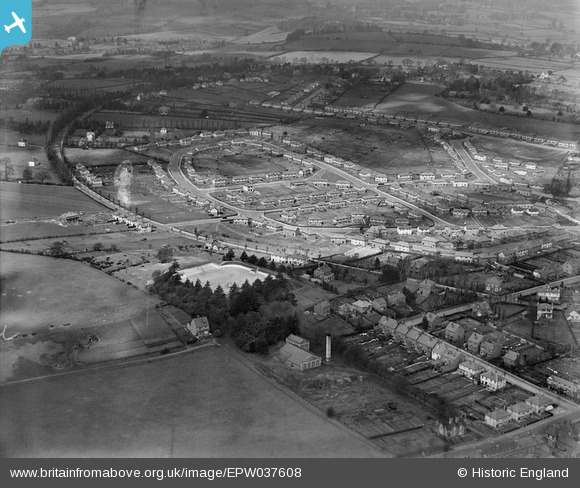
epw037608 ENGLAND (1932). The Sutton Farm housing estate, Kidderminster, from the south-east, 1932
© Copyright OpenStreetMap contributors and licensed by the OpenStreetMap Foundation. 2024. Cartography is licensed as CC BY-SA.
Details
| Title | [EPW037608] The Sutton Farm housing estate, Kidderminster, from the south-east, 1932 |
| Reference | EPW037608 |
| Date | April-1932 |
| Link | |
| Place name | KIDDERMINSTER |
| Parish | |
| District | |
| Country | ENGLAND |
| Easting / Northing | 382221, 275201 |
| Longitude / Latitude | -2.2611866957773, 52.374180939466 |
| National Grid Reference | SO822752 |
Pins
 emmah |
Monday 27th of February 2017 03:53:16 PM | |
emmah |
Wednesday 22nd of February 2017 10:34:11 AM | |
emmah |
Wednesday 22nd of February 2017 10:28:07 AM | |
emmah |
Wednesday 22nd of February 2017 10:27:37 AM | |
emmah |
Wednesday 22nd of February 2017 10:26:48 AM | |
Nickyt |
Sunday 8th of March 2015 09:48:36 PM | |
Nickyt |
Sunday 8th of March 2015 09:46:50 PM | |
Nickyt |
Sunday 8th of March 2015 09:45:01 PM | |
Nickyt |
Sunday 8th of March 2015 09:44:06 PM | |
Nickyt |
Sunday 8th of March 2015 09:41:15 PM | |
Nickyt |
Sunday 8th of March 2015 09:41:13 PM | |
Nickyt |
Sunday 8th of March 2015 09:08:43 PM | |
Nickyt |
Sunday 8th of March 2015 09:06:52 PM | |
Nickyt |
Sunday 8th of March 2015 09:06:02 PM | |
Nickyt |
Sunday 8th of March 2015 10:13:30 AM |


