
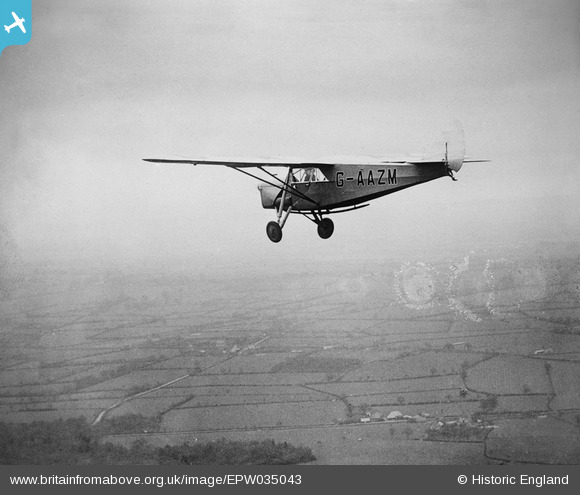
epw035043 ENGLAND (1931). DH80A Puss Moth G-AAZM in flight over Frith Farm, Pluckley, 1931
© Copyright OpenStreetMap contributors and licensed by the OpenStreetMap Foundation. 2024. Cartography is licensed as CC BY-SA.
Nearby Images (2)
EPW035043

EPW035043A

Details
| Title | [EPW035043] DH80A Puss Moth G-AAZM in flight over Frith Farm, Pluckley, 1931 |
| Reference | EPW035043 |
| Date | April-1931 |
| Link | |
| Place name | PLUCKLEY |
| Parish | PLUCKLEY |
| District | |
| Country | ENGLAND |
| Easting / Northing | 590562, 144868 |
| Longitude / Latitude | 0.72623101568546, 51.170734681712 |
| National Grid Reference | TQ906449 |
Pins
 (Custom).jpg) jael |
Friday 11th of January 2013 04:55:11 PM | |
 Class31 |
Sunday 6th of January 2013 04:09:44 PM | |
Class31 |
Sunday 6th of January 2013 04:09:16 PM | |
Class31 |
Sunday 6th of January 2013 04:08:47 PM | |
 Tony D |
Sunday 6th of January 2013 03:13:40 PM | |
Tony D |
Sunday 6th of January 2013 03:12:20 PM |
User Comment Contributions
Edge of Dering Wood in Kent, looking north. Taken just after EPW035044. Cropped version of EPW035043A? |
Tony D |
Friday 8th of March 2013 01:43:55 PM |
Well done Tony D for getting this series. There was not a lot to go on. |
Class31 |
Sunday 6th of January 2013 04:11:36 PM |
Thanks. I got a bit lucky - chose a random railway in the south of England and recognised the woods in seconds - not a lot has changed. I wonder where EPW035042 is? Presumably somewhere on the same track. |
Tony D |
Sunday 6th of January 2013 04:20:21 PM |
EPW035042 is indeed on the same track, 4 or 5 miles west. |
Tony D |
Tuesday 8th of January 2013 12:56:48 PM |
Great spot Tony D, thank you! We'll update the catalogue, and post the new location data here in due course. Yours, Katy Britain from Above Cataloguing Team Leader |
Katy Whitaker |
Friday 8th of March 2013 01:43:55 PM |


