
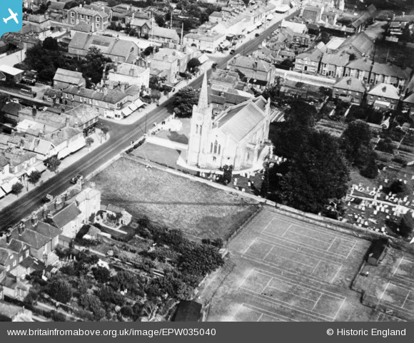
epw035040 ENGLAND (1931). Holy Trinity Church, Fareham, 1931
© Copyright OpenStreetMap contributors and licensed by the OpenStreetMap Foundation. 2024. Cartography is licensed as CC BY-SA.
Details
| Title | [EPW035040] Holy Trinity Church, Fareham, 1931 |
| Reference | EPW035040 |
| Date | 1931 |
| Link | |
| Place name | FAREHAM |
| Parish | |
| District | |
| Country | ENGLAND |
| Easting / Northing | 457563, 106177 |
| Longitude / Latitude | -1.1821792774977, 50.851684153221 |
| National Grid Reference | SU576062 |
Pins
 MikePilot&Navigator |
Monday 17th of September 2018 08:16:06 PM | |
MikePilot&Navigator |
Monday 17th of September 2018 08:06:12 PM | |
Sweet Pete |
Monday 23rd of February 2015 12:22:17 PM | |
Sweet Pete |
Sunday 22nd of February 2015 10:11:58 PM | |
Sweet Pete |
Sunday 22nd of February 2015 10:10:20 PM | |
Sweet Pete |
Sunday 22nd of February 2015 10:09:55 PM | |
 Class31 |
Sunday 22nd of February 2015 07:35:52 PM | |
Class31 |
Sunday 22nd of February 2015 07:24:43 PM | |
Sweet Pete |
Sunday 22nd of February 2015 05:59:47 PM | |
Well done Sweet Pete in getting the location of this photo. Many of us have tried to locate this one and failed and you have found the resolution. As an aside I was in the area on 16th October and took the enclosed photographs and failed to make the connection. This one could have been anywhere and turns out to be Fareham. Once again well done. |
Class31 |
Sunday 22nd of February 2015 07:30:47 PM |
Maitland |
Sunday 16th of November 2014 01:39:03 AM | |
Maitland |
Sunday 16th of November 2014 01:30:11 AM | |
This is the Royal Oak Public House. |
Sweet Pete |
Sunday 22nd of February 2015 10:26:50 PM |
James Chandler |
Saturday 15th of November 2014 09:10:27 PM | |
Yes, this is the memorial erected in 1921 to the memory of the men of Fareham that gave their lives in the 1914-18 war and it sits before the entrance to the Holy Trinity Church. |
Sweet Pete |
Sunday 22nd of February 2015 10:42:55 PM |
Curlew |
Saturday 15th of November 2014 07:25:35 PM | |
You won't find it there! This is the Holy Trinity Church in Fareham. |
Sweet Pete |
Sunday 22nd of February 2015 06:02:44 PM |
Curlew |
Saturday 15th of November 2014 07:24:13 PM | |
These are the Fareham parish tennis courts which were built on in the 1960's |
Sweet Pete |
Monday 23rd of February 2015 01:26:26 PM |
Chris Willis |
Wednesday 12th of November 2014 09:10:29 PM | |
On close inspection it looks more like an aerial (radio?)of some description. |
mannidaze |
Saturday 15th of November 2014 08:32:24 PM |
They are BBC radio transmitters which were erected circa 1931. |
Sweet Pete |
Sunday 22nd of February 2015 10:49:36 PM |
Graeme |
Thursday 30th of October 2014 04:41:46 PM | |
I can't see any overhead wires, which suggests this must be within the London County Council area (conduit current collection) |
mannidaze |
Saturday 15th of November 2014 08:30:40 PM |
Definitely no overhead - and no conduit obvious either. Street railway. Not many of these in UK- WCPR, Westward Ho! demolished by the era of aerial photography, where else? |
Maitland |
Sunday 16th of November 2014 01:36:38 AM |
mannidaze, if these were LCC tram lines the central conduit would normally be visible. However, there were actually some later extensions to LCC lines within the LCC boundary, and these had overhead wires, and not conduit. |
Isleworth1961 |
Monday 24th of November 2014 09:02:03 PM |
Yes, these are tram lines and the service was run by the Provincial Tram Company. This was originally a horse drawn service between Fareham and Gosport. In the picture I cannot see any overhead lines (the trams were electrified in 1906) and it looks to me as though the tracks have been removed and what you can see is actually the mark left on the road. The tram ran until 1929 so I'm guessing this photo is post 1929. |
Sweet Pete |
Sunday 22nd of February 2015 06:04:41 PM |

User Comment Contributions
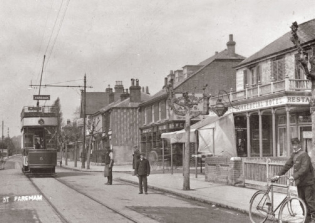 This is the Royal Oak in West Street, on the corner of Trinty Street |
Sweet Pete |
Sunday 22nd of February 2015 10:58:18 PM |
 Milepost, Fareham, 16/10/2014 |
Class31 |
Sunday 22nd of February 2015 07:25:58 PM |
 Holy Trinity Church and War Memorial, Fareham, 16/10/2014 |
Class31 |
Sunday 22nd of February 2015 07:17:44 PM |
 Holy Trinity Church and War Memorial, Fareham, 16/10/2014 |
Class31 |
Sunday 22nd of February 2015 07:17:01 PM |
Not sure, but think this is very possibly St Lawrence, Brentford High Street. The Old-Maps are pretty crippled now, but the National Library of SDcotland has a decent image of the 1:1056 1890s map. |
Chris Willis |
Monday 17th of November 2014 01:05:00 AM |
No. Doesn't match other picture of St Laurence epw005294. |
Chris Willis |
Monday 17th of November 2014 01:05:00 AM |
EPW035041 is of The Great West Road and environs, Hounslow, from the south-west, 1931 taken 1931 |
Class31 |
Saturday 15th of November 2014 08:28:41 PM |
Possibly not Hounslow. If those are tram tracks there do not appear to be any overhead wires,which means it must be within the London County Council area, where conduit current collection was employed, whereas at the time this photo was taken the Hounslow area was served by London United Tramways with conventional overhead collection. |
mannidaze |
Saturday 15th of November 2014 08:28:41 PM |
EPW035039 is of The Metropolitan and District railway crossing under the Great West Road and environs, Osterley, 1931 taken April 1931 |
Class31 |
Wednesday 12th of November 2014 08:43:01 AM |


