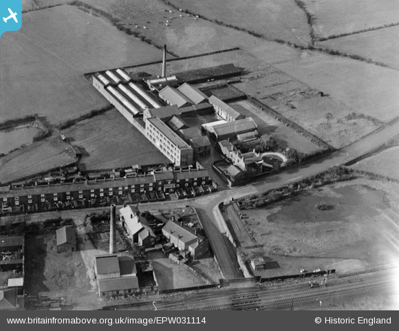
epw031114 ENGLAND (1929). Stothert's Albion Drugs and Drysaltery Works, Atherton, 1929
© Copyright OpenStreetMap contributors and licensed by the OpenStreetMap Foundation. 2024. Cartography is licensed as CC BY-SA.
Nearby Images (10)
Details
| Title | [EPW031114] Stothert's Albion Drugs and Drysaltery Works, Atherton, 1929 |
| Reference | EPW031114 |
| Date | October-1929 |
| Link | |
| Place name | ATHERTON |
| Parish | |
| District | |
| Country | ENGLAND |
| Easting / Northing | 366667, 404062 |
| Longitude / Latitude | -2.5029418236082, 53.531909448021 |
| National Grid Reference | SD667041 |
Pins
Be the first to add a comment to this image!


![[EPW031114] Stothert's Albion Drugs and Drysaltery Works, Atherton, 1929](http://britainfromabove.org.uk/sites/all/libraries/aerofilms-images/public/100x100/EPW/031/EPW031114.jpg)
![[EPR000574] Stothert's Ltd Albion Drug and Drysaltery Works, Atherton, 1935. This image was marked by Aero Pictorial Ltd for photo editing.](http://britainfromabove.org.uk/sites/all/libraries/aerofilms-images/public/100x100/EPR/000/EPR000574.jpg)
![[EPR000579] Stothert's Ltd Albion Drug and Drysaltery Works, Atherton, 1935. This image has been produced from a damaged negative.](http://britainfromabove.org.uk/sites/all/libraries/aerofilms-images/public/100x100/EPR/000/EPR000579.jpg)
![[EPR000577] Stothert's Ltd Albion Drug and Drysaltery Works, Atherton, 1935. This image was marked by Aero Pictorial Ltd for photo editing.](http://britainfromabove.org.uk/sites/all/libraries/aerofilms-images/public/100x100/EPR/000/EPR000577.jpg)
![[EPR000575] Stothert's Ltd Albion Drug and Drysaltery Works, Atherton, 1935](http://britainfromabove.org.uk/sites/all/libraries/aerofilms-images/public/100x100/EPR/000/EPR000575.jpg)
![[EPW031127] Stothert's Albion Drugs and Drysaltery Works, Atherton, 1929](http://britainfromabove.org.uk/sites/all/libraries/aerofilms-images/public/100x100/EPW/031/EPW031127.jpg)
![[EPW031110] Stothert's Albion Drugs and Drysaltery Works, Atherton, 1929](http://britainfromabove.org.uk/sites/all/libraries/aerofilms-images/public/100x100/EPW/031/EPW031110.jpg)
![[EPR000576] Stothert's Ltd Albion Drug and Drysaltery Works, Atherton, 1935. This image was marked by Aero Pictorial Ltd for photo editing.](http://britainfromabove.org.uk/sites/all/libraries/aerofilms-images/public/100x100/EPR/000/EPR000576.jpg)
![[EPW031182] Stothert's Ltd. Albion Drug and Drysaltery Works, Atherton, 1929](http://britainfromabove.org.uk/sites/all/libraries/aerofilms-images/public/100x100/EPW/031/EPW031182.jpg)
![[EPW031115] Stothert's Albion Drugs and Drysaltery Works, Atherton, 1929](http://britainfromabove.org.uk/sites/all/libraries/aerofilms-images/public/100x100/EPW/031/EPW031115.jpg)


