
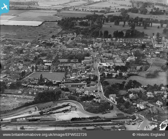
epw022726 ENGLAND (1928). The town, Farnham, from the south-east, 1928
© Copyright OpenStreetMap contributors and licensed by the OpenStreetMap Foundation. 2024. Cartography is licensed as CC BY-SA.
Nearby Images (2)
EPW022726

EPW032699

Details
| Title | [EPW022726] The town, Farnham, from the south-east, 1928 |
| Reference | EPW022726 |
| Date | August-1928 |
| Link | |
| Place name | FARNHAM |
| Parish | FARNHAM |
| District | |
| Country | ENGLAND |
| Easting / Northing | 484344, 146580 |
| Longitude / Latitude | -0.7923604994675, 51.211671505162 |
| National Grid Reference | SU843466 |
Pins
 Dee |
Sunday 10th of October 2021 08:03:57 PM | |
David960 |
Saturday 21st of February 2015 11:18:15 AM | |
flubber |
Thursday 15th of August 2013 06:24:44 PM | |
Ian Sargeant |
Friday 3rd of May 2013 05:20:56 PM | |
Bob Paine |
Thursday 24th of January 2013 07:03:39 AM | |
MB |
Sunday 21st of October 2012 10:54:05 AM | |
MB |
Sunday 21st of October 2012 10:52:23 AM | |
MB |
Sunday 21st of October 2012 10:49:54 AM | |
MB |
Sunday 21st of October 2012 10:48:43 AM | |
MB |
Sunday 21st of October 2012 10:43:19 AM | |
MB |
Sunday 21st of October 2012 10:42:41 AM | |
flubber |
Thursday 20th of September 2012 12:19:17 AM | |
The box subsequently closed in 2013 and was later demolished. |
Roger Merry-Price |
Saturday 4th of July 2020 04:23:44 PM |
Robot Archie |
Sunday 26th of August 2012 08:53:53 PM | |
Robot Archie |
Sunday 26th of August 2012 08:53:05 PM | |
Robot Archie |
Sunday 26th of August 2012 08:51:47 PM | |
Robot Archie |
Sunday 26th of August 2012 08:50:44 PM | |
Originally named The Railway Arms, then The Railway Hotel and then Blue Boy. See Parratt,J: Licensed Farnham. Never a 'temperance hotel', that was on the opposite side of the road and known as Railway Temperance Hotel. See Francis Frith Collection - Photo: Farnham Station Road 1904 No. 51604 |
Bob Paine |
Thursday 6th of November 2014 10:58:46 AM |
Robot Archie |
Sunday 26th of August 2012 08:46:13 PM | |
Robot Archie |
Sunday 26th of August 2012 08:44:16 PM | |
flubber |
Friday 6th of July 2012 12:05:15 AM | |
flubber |
Thursday 5th of July 2012 11:58:25 PM | |
flubber |
Monday 2nd of July 2012 04:03:59 PM | |
This pointer may be by the gatehouse, which dates from the thirteenth century |
MB |
Sunday 21st of October 2012 10:44:42 AM |
flubber |
Monday 2nd of July 2012 04:00:14 PM | |
flubber |
Monday 2nd of July 2012 03:57:44 PM | |
flubber |
Monday 2nd of July 2012 03:55:19 PM | |
flubber |
Monday 2nd of July 2012 03:53:44 PM | |
flubber |
Monday 2nd of July 2012 03:52:12 PM | |
Peter Smart |
Thursday 28th of June 2012 03:13:25 PM | |
Peter Smart |
Thursday 28th of June 2012 03:06:45 PM | |
Peter Smart |
Thursday 28th of June 2012 03:05:35 PM | |
Peter Smart |
Thursday 28th of June 2012 03:04:38 PM |
User Comment Contributions
This scene is now dissected by the A31! |
Good Old Uncle Ted |
Friday 29th of June 2012 02:53:38 PM |


