
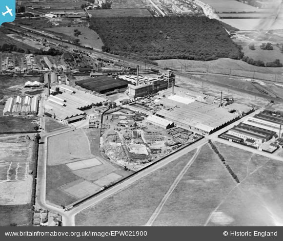
epw021900 ENGLAND (1928). Factories on Rubastic Road, Southall, 1928
© Copyright OpenStreetMap contributors and licensed by the OpenStreetMap Foundation. 2024. Cartography is licensed as CC BY-SA.
Details
| Title | [EPW021900] Factories on Rubastic Road, Southall, 1928 |
| Reference | EPW021900 |
| Date | July-1928 |
| Link | |
| Place name | SOUTHALL |
| Parish | |
| District | |
| Country | ENGLAND |
| Easting / Northing | 511021, 179248 |
| Longitude / Latitude | -0.40034038688496, 51.500768278861 |
| National Grid Reference | TQ110792 |
Pins
 weh |
Monday 24th of April 2017 11:59:47 PM | |
This was Ticklers Jam factory and was a different factory to Kearley and Tonge that was on the adjacent site. |
weh |
Wednesday 29th of May 2019 12:11:07 PM |
weh |
Monday 24th of April 2017 11:54:18 PM | |
Kazzie |
Wednesday 22nd of August 2012 10:36:57 PM | |
Tickers and Kearley & Tonge were separate factories. Ticlkers closed before Kearley & Tonge. |
weh |
Monday 24th of April 2017 11:52:16 PM |
Ticklers and Kearley and Tonge were always separate factories. Ticklers closed first and Kearley and Tonge some time later. Part of Ticklers became Arrow Switches Factory. My father worked in Kearley and Tonge in the 1970s Ticklers was well known in WW1 for supplying plum and apple jam in tins. The tins were used in the early years of WW1 for Ticklers Artillery which was making grenades from the tins. Kearley and Tonge supplied the International Stores with preserves etc. and confectionary etc. |
weh |
Wednesday 29th of May 2019 12:08:26 PM |
 Class31 |
Saturday 4th of August 2012 10:47:36 PM | |
Class31 |
Saturday 4th of August 2012 10:46:23 PM | |
Class31 |
Saturday 4th of August 2012 10:45:46 PM | |
Class31 |
Saturday 4th of August 2012 10:41:54 PM | |
Mike |
Friday 27th of July 2012 01:48:02 PM | |
longshot |
Sunday 15th of July 2012 12:44:17 AM | |
The tunnel under the mainline railway had a small locked gate. This was a private entrance to the gasworks and was used by my father. It is now a road leading to the airport parking facility and car storage etc. |
weh |
Sunday 3rd of February 2013 04:57:00 PM |
Isleworth1961 |
Saturday 14th of July 2012 04:31:22 PM | |
Crown Cork is in Scotts Rd, Southall, Middlesex |
annie.jk |
Friday 20th of July 2012 02:37:24 PM |
Isleworth1961 |
Saturday 14th of July 2012 04:30:47 PM | |
Ticklers Jam factory and later Arrow Switches |
weh |
Monday 24th of April 2017 11:48:46 PM |
Isleworth1961 |
Saturday 14th of July 2012 04:29:18 PM | |
Isleworth1961 |
Saturday 14th of July 2012 04:28:32 PM | |
D Figueiredo |
Wednesday 4th of July 2012 02:20:27 PM | |
D Figueiredo |
Wednesday 4th of July 2012 02:16:28 PM | |
This is Birchway, Hayes. Just to the South is Minet Drive |
Mike |
Friday 27th of July 2012 01:48:57 PM |
Glen37037 |
Tuesday 3rd of July 2012 09:44:29 AM | |
This is very close to Bulls Bridge Junction, Southall |
Mike |
Friday 27th of July 2012 01:44:08 PM |
This is the Paddington Branch canal which it joins the Grand Union Canal at Bulls Bridge. |
weh |
Monday 24th of April 2017 11:58:07 PM |
kinmel |
Saturday 30th of June 2012 08:52:51 AM | |
My boyhood home in Brent Road looked across to lines of barrels in Ticklers yard. They contained the fruit pulp for the manufacture of jam. Some WW1 trench photographs show tins with Ticklers name on the labels. The fruit was delivered to the railway siding at the end of Brent Road and received in a large wooden building. I was told that this building was originally used for the manufacture of armaments in WW1. |
weh |
Sunday 3rd of February 2013 04:49:54 PM |
EastMarple1 |
Friday 29th of June 2012 05:40:27 PM | |
TheBlueCube |
Friday 29th of June 2012 11:06:24 AM | |
That looks very much like a brewery. That would figure with the barrels. |
Tiny Tim |
Sunday 1st of July 2012 05:31:20 PM |
User Comment Contributions
Right! Dave Brunt has finally located the site correctly. But this is actually SOUTHALL, not Hayes, and looking in the direction of Hayes. That canal is the Paddington arm of the Grand Union, and as the factories are to the east of it, they are definitely in Southall (the Hayes/Southall boundary is the Yeading Brook, just to the west of the canal. The tall brick-built factory was originally the Rubastic Works, and I gather they made golf balls, among other things. Kearley and Tonge's jam factory (opened 1913?) is to the right of it, and the factory to the extreme right of the photo is the Crown Cork Company (opened 1922, on the site of a previous wallpaper factory). The 'goods depot' is the GWR's sleeper creosoting depot. Bull's Bridge is just out of shot to the left, as is the 'Main Line' of the Grand Union to Brentford. The woods the other side of the railway are now housing and trading estates, in Hayes. |
Isleworth1961 |
Thursday 30th of May 2013 05:10:40 PM |
I believe that Ticklers and Kearley & Tonge were two separate food factories. Kearley & Tongue became International Stores and dealt in a wide range of grocery items. The large tower was used by them for the manufacture of confectionary. The canal visible is the northern branch of the Grand Union canal with the junction at Bulls Bridge just out of sight on the left. The view is definitely in Southall and I lived in Brent Road for many years in a house built in 1933/34. |
weh |
Sunday 3rd of February 2013 05:05:18 PM |
10/10 well done you know your stuff |
southallboy |
Thursday 30th of May 2013 05:10:40 PM |
 Photograph taken in about 1960 looking across Brent Road to what was Tickler Jam Factory and yard. |
weh |
Monday 4th of February 2013 11:21:22 AM |
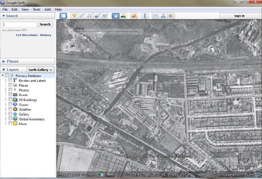 OK so here is the 1945 google earth photo of the place. You can clearly see the road layout matches as does most of the industrial buildings. The wood in the back of the picture has been reduced to a line of trees outlining where it was |
Dave Brunt |
Wednesday 24th of October 2012 09:39:47 AM |
Dear Dave, That’s great; thanks to your help we can update the catalogue. The revised record will appear here in due course. The information that everyone has posted about the image is very useful. You may be interested to know that the original Aerofilms Ltd Register entry says "International Stores, wash out". Yours, Katy Britain from Above Cataloguing Team Leader |
Katy Whitaker |
Wednesday 24th of October 2012 09:39:47 AM |
So the straight road from bottom left to mid right under the little railbridge is Brent Rd? (leading to 'Purple Parking' on Google Earth) |
longshot |
Saturday 14th of July 2012 11:27:46 PM |
Exactly. |
Isleworth1961 |
Saturday 14th of July 2012 11:27:46 PM |
Yes, I agree,not Hayes even reversed, canal too straight,no station, either...but where is it? |
longshot |
Saturday 14th of July 2012 11:46:29 AM |
No, even when it's reversed, it's not Hayes. The original cocoa factory block was more or less at a right angle to the canal, while here it's seen at a right angle to the railway. There are too many 'shed' type buildings seen here, which the cocoa factory, or Nestle's didn't have. Comparing maps with the photo, Nestle's Avenue would have therefore been built through the south of the factory site - which it wasn't. At Hayes, the canal is pretty straight where it passes through the factories area, while in the photo it has a curve In reality the railway is on a gentle curve - here it looks much too straight. The railway goods yard that can be seen - there definitely wasn't one in this location at Hayes, which had it to the north of the station, which if it was Hayes, would be out of shot to the left. Those woods opposite the railway don't appear on any old maps of Hayes, and what are the roads to be seen at the top? NOT Hayes. |
Isleworth1961 |
Friday 13th of July 2012 10:28:25 PM |
Is it Hayes but printed in reverse L-R?...try this http://www.flickr.com/photos/74784995@N00/7561969434/sizes/l/in/photostream/ |
longshot |
Friday 13th of July 2012 03:15:58 PM |
Sorry guys, I don't know where it is, but no way is this Hayes! The railway line crosses what appears to be a canal at the wrong angle (just look at a map of the area), and from photos I have, the factory certainly is not Nestle's or it's predecessor. Also, Hayes station's good yard was on the north, and opposite side of the railway from Nestle's, and those woods in the location of where the middle of Hayes town would be! |
Isleworth1961 |
Wednesday 11th of July 2012 11:52:30 PM |
The road running vertically up the left hand side is 'Trident Way' The diagonal road from the bottom left is 'Brent road' The location is correct and those woods are now Hayes Town! |
Dave Brunt |
Wednesday 11th of July 2012 11:52:30 PM |
That's it! It's what became the Nestles site the year after this photo was taken. The clincher is the signwriting on the tower; the bottom line reads 'Sandow' the name of the original cocoa company that built the factory. |
Tiny Tim |
Thursday 5th of July 2012 04:05:08 PM |
This is vaguely reminiscent of the Nestle Factory complex in the Hayes area on the Grand Union Canal in Middlesex. The GW railway does craft the canal on the skew by the factory even today. If it is Hayes then there should be Victorian housing off the left of the picture and to the right a short distance away a gas works (southall) and the junction with the Paddington Arm of the Grand Union canal and an electricity substation. In the top left corner of the picture is another factory building. At teh top middle right there is a new housing estate appearing. |
D Figueiredo |
Thursday 5th of July 2012 01:35:54 AM |
The road layout matches and most of the buildings are still on the 1945 Google Earth images |
Dave Brunt |
Thursday 5th of July 2012 01:35:54 AM |
The main building / complex in the centre foreground looks like it might be a brewery. There is a/are name/s on the square tower on the right end of the mill building but I can't make it out.!! |
TheBlueCube |
Friday 29th of June 2012 11:05:43 AM |


