
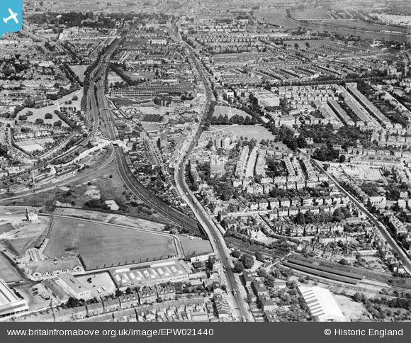
epw021440 ENGLAND (1928). The Acton Curve and Chiswick High Road, Gunnersbury, from the west, 1928
© Copyright OpenStreetMap contributors and licensed by the OpenStreetMap Foundation. 2024. Cartography is licensed as CC BY-SA.
Nearby Images (9)
EPW021440

EPW024934
 Works, Gunnersbury, from the south-east, 1928")
EPW010680
 Works, Gunnersbury, 1924")
EPW007143
 and environs, Gunnersbury, 1921")
EPW005263

EPW007144
 and environs, Gunnersbury, 1921")
EPW007140
, Gunnersbury, 1921")
EPW007141
, Gunnersbury, 1921")
EPW010677
 Works, Gunnersbury, 1924")
Details
| Title | [EPW021440] The Acton Curve and Chiswick High Road, Gunnersbury, from the west, 1928 |
| Reference | EPW021440 |
| Date | 30-May-1928 |
| Link | |
| Place name | GUNNERSBURY |
| Parish | |
| District | |
| Country | ENGLAND |
| Easting / Northing | 519875, 178480 |
| Longitude / Latitude | -0.27308744063194, 51.492056405643 |
| National Grid Reference | TQ199785 |
Pins
 Floss63 |
Friday 22nd of March 2024 09:54:01 PM | |
Kentishman |
Tuesday 18th of October 2022 08:42:34 AM | |
Kentishman |
Tuesday 18th of October 2022 08:31:49 AM | |
waylou |
Wednesday 21st of April 2021 04:01:25 PM | |
waylou |
Wednesday 21st of April 2021 03:55:54 PM | |
douglasgray |
Wednesday 9th of December 2020 01:11:44 AM | |
John W |
Friday 23rd of September 2016 08:53:33 PM | |
 Des Elmes |
Wednesday 6th of April 2016 12:55:28 AM | |
Des Elmes |
Wednesday 6th of April 2016 12:54:44 AM | |
Leslie B |
Friday 11th of March 2016 05:57:29 PM | |
 Class31 |
Tuesday 1st of September 2015 09:39:23 AM | |
 |
Class31 |
Tuesday 1st of September 2015 09:38:12 AM |
Class31 |
Tuesday 1st of September 2015 09:36:08 AM | |
FermePark |
Friday 15th of March 2013 12:28:32 AM | |
roadrunner66 |
Wednesday 23rd of January 2013 11:10:47 PM | |
Isleworth1961 |
Thursday 2nd of August 2012 10:48:55 AM | |
Isleworth1961 |
Sunday 15th of July 2012 01:03:57 AM | |
Isleworth1961 |
Sunday 15th of July 2012 01:01:55 AM |


User Comment Contributions
 Chiswick High Road, A315, 25/05/2015 |
Class31 |
Tuesday 1st of September 2015 09:37:12 AM |
This Picture was taken 4 years before the 4-tracking of old 2-track formation West of Turnham Green station (top left) to accommodate Westward extension of Piccadilly line from Hammersmith; Bottom right - Gunnersbury Station and East Junction before reduction to a single island platform layout; Top of triangular railway junctions just before (white) road over-bridge is Acton Lane Junction signal box; to left of that is Chiswick Park & Acton Green station. The chord line joining the "main" line from Gunnersbury at Acton Lane Jn was closed in 1965 - it carried coal traffic from Brent Sidings to both West Kensington and High Street Kensington goods yards. The pair of tracks heading from Acton Lane Jn towards Turnham Green, passing under the District tracks en route, were part of the L&SWR route from Kensington Addison Road (now Olympia) to Richmond, which used the former viaduct between Ravenscourt Park and Hammersmith (part of which can still be seen today) to pass alongside the Hammersmith & City line station and then under the line near the bus depot building. The route was taken out of use around the time of WW1. Prior to the Piccadilly extension the northern pair of tracks between Turnham Green and Ravenscourt Park (Hammersmith) were disused from c 1914 with the southern pair being used by the District line (officially the Metropolitan District originally). This area has a fascinating railway history, of which the above is only a snapshot. |
Russell |
Monday 30th of July 2012 04:39:28 PM |