
epw020992 ENGLAND (1928). Oxhey Park Golf Course and Club House, Oxhey Hall, 1928
© Copyright OpenStreetMap contributors and licensed by the OpenStreetMap Foundation. 2025. Cartography is licensed as CC BY-SA.
Nearby Images (2)
EPW020992

EPW020993

Details
| Title | [EPW020992] Oxhey Park Golf Course and Club House, Oxhey Hall, 1928 |
| Reference | EPW020992 |
| Date | April-1928 |
| Link | |
| Place name | OXHEY HALL |
| Parish | WATFORD RURAL |
| District | |
| Country | ENGLAND |
| Easting / Northing | 511271, 193919 |
| Longitude / Latitude | -0.39209356639444, 51.632594829362 |
| National Grid Reference | TQ113939 |
Pins
Be the first to add a comment to this image!
User Comment Contributions
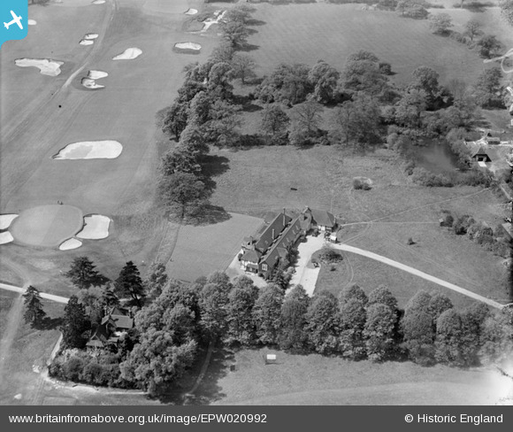
 An attractive composition of the 1912 Oxhey Golf Clubhouse, with a view of the 18th green on the course's original layout 1912-1936. This famous old course hosted tournaments throughout the interwar years, including the prestigious "News of the World" competitions. The construction of the huge, postwar housing estate at South Oxhey, accommodating over 17,000 folk, in the 1940s resulted in the loss of more than 25% of the playing area at the east end and in the south-east corner of the links, and the club eventually closed in October 1946. A municipal course struggled on until March 1952, when it became the South Oxhey Playing Fields. The fine clubhouse has since been extended and is now "The Pavillion" restaurant, with a spacious car park on its northern side and a bowling green, with tennis courts, to the west. Since the demise of the golf course, the highly-prized facility of the playing fields has hosted several sports teams in over six decades and the varied topography has attracted regular visits from the Thames Valley Orienteering Club!! A fine example of the positive uses made of valuable Green Belt land, close to the northern boundary of Greater London. |
 John Swain |
Tuesday 14th of May 2013 09:44:46 AM |
 Oxhey Golf Course in 1920, a plan which I drew in 2003 after lengthy consultations with golf historian, Don Dunham, and local historian, Neil Hamilton. The original map is currently on display in the Oxhey Park Golf Clubhouse, Prestwick Road, South Oxhey. The layout was considerably altered in 1936 to achieve a better balance between the front nine and back nine holes. |
John Swain |
Wednesday 11th of July 2012 02:59:08 PM |
This image shows the 1912 Oxhey Golf Clubhouse and the practice putting green, next to the 18th green, in a view looking west up the championship course. The full course measured a long 6,539 yards and the Standard Scratch Score was 78. The golf course was designed by Harry Vardon and the professional was fellow-Channel Islander, Ted Ray, who was appointed from 1912 until his retirement in 1940. |
John Swain |
Tuesday 10th of July 2012 03:13:39 PM |