
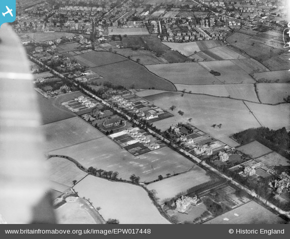
epw017448 ENGLAND (1927). St John's Church and Brooklands Road, Brooklands, 1927
© Copyright OpenStreetMap contributors and licensed by the OpenStreetMap Foundation. 2024. Cartography is licensed as CC BY-SA.
Details
| Title | [EPW017448] St John's Church and Brooklands Road, Brooklands, 1927 |
| Reference | EPW017448 |
| Date | 8-March-1927 |
| Link | |
| Place name | BROOKLANDS |
| Parish | |
| District | |
| Country | ENGLAND |
| Easting / Northing | 378992, 390355 |
| Longitude / Latitude | -2.3160645044207, 53.40932970001 |
| National Grid Reference | SJ790904 |
Pins
 NeilO |
Sunday 14th of October 2018 03:56:42 PM | |
NeilO |
Sunday 14th of October 2018 03:54:57 PM | |
John Ellis |
Sunday 17th of March 2013 09:44:04 PM | |
John Ellis |
Monday 5th of November 2012 09:59:43 PM | |
John Ellis |
Friday 17th of August 2012 09:09:34 PM | |
John Ellis |
Friday 27th of July 2012 04:42:52 PM | |
John Ellis |
Friday 27th of July 2012 04:41:53 PM | |
John Ellis |
Friday 27th of July 2012 04:39:56 PM | |
John Ellis |
Friday 27th of July 2012 04:39:11 PM | |
John Ellis |
Friday 27th of July 2012 04:38:20 PM | |
John Ellis |
Friday 27th of July 2012 04:29:53 PM | |
John Ellis |
Friday 27th of July 2012 04:27:51 PM | |
John Ellis |
Friday 27th of July 2012 04:27:22 PM | |
John Ellis |
Friday 27th of July 2012 04:26:22 PM | |
John Ellis |
Friday 27th of July 2012 04:25:19 PM | |
John Ellis |
Friday 27th of July 2012 04:23:59 PM | |
John Ellis |
Friday 27th of July 2012 04:22:39 PM | |
John Ellis |
Friday 27th of July 2012 04:22:08 PM | |
John Ellis |
Friday 27th of July 2012 04:21:36 PM | |
John Ellis |
Thursday 5th of July 2012 08:36:12 PM | |
John Ellis |
Thursday 5th of July 2012 08:35:30 PM | |
This is Georges Road.. Beaufort Road is to the East (Right on the photo). In 1927, the length of Whitehall Rd between Georges Road and Beaufort Rd had not been built. |
ahorsfall |
Sunday 23rd of December 2012 10:40:31 PM |
You're quite right - my mistake! |
John Ellis |
Sunday 17th of March 2013 09:42:04 PM |
John Ellis |
Thursday 5th of July 2012 08:34:45 PM | |
John Ellis |
Thursday 5th of July 2012 08:32:25 PM | |
John Ellis |
Thursday 5th of July 2012 08:26:50 PM | |
Became Rowantree Drive, 8x 4 bed detached houses. |
Marni1971 |
Wednesday 18th of July 2012 04:20:29 PM |
John Ellis |
Thursday 5th of July 2012 08:22:49 PM | |
John Ellis |
Thursday 5th of July 2012 08:21:53 PM | |
John Ellis |
Thursday 5th of July 2012 08:20:08 PM | |
John Ellis |
Tuesday 3rd of July 2012 06:01:31 PM | |
John Ellis |
Tuesday 3rd of July 2012 05:48:23 PM | |
John Ellis |
Tuesday 3rd of July 2012 05:46:43 PM | |
John Ellis |
Tuesday 3rd of July 2012 05:44:44 PM | |
John Ellis |
Tuesday 3rd of July 2012 05:43:41 PM | |
John Ellis |
Tuesday 3rd of July 2012 05:43:03 PM | |
John Ellis |
Tuesday 3rd of July 2012 05:41:44 PM | |
John Ellis |
Tuesday 3rd of July 2012 02:10:07 PM |


