
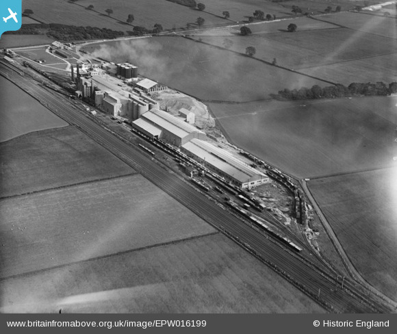
epw016199 ENGLAND (1926). The Humber Cement Works, Welton, 1926
© Copyright OpenStreetMap contributors and licensed by the OpenStreetMap Foundation. 2024. Cartography is licensed as CC BY-SA.
Nearby Images (2)
EPW016199

EPW016201

Details
| Title | [EPW016199] The Humber Cement Works, Welton, 1926 |
| Reference | EPW016199 |
| Date | July-1926 |
| Link | |
| Place name | WELTON |
| Parish | WELTON |
| District | |
| Country | ENGLAND |
| Easting / Northing | 496493, 425788 |
| Longitude / Latitude | -0.53756721440639, 53.719343408713 |
| National Grid Reference | SE965258 |
Pins
 Dylan Moore |
Monday 22nd of October 2012 04:47:08 PM | |
Dylan Moore |
Monday 22nd of October 2012 04:46:24 PM | |
Dylan Moore |
Monday 22nd of October 2012 04:45:54 PM | |
Dylan Moore |
Monday 22nd of October 2012 04:44:53 PM | |
Dylan Moore |
Monday 22nd of October 2012 04:44:02 PM | |
Dylan Moore |
Monday 22nd of October 2012 04:43:31 PM | |
Dylan Moore |
Monday 22nd of October 2012 04:42:48 PM | |
Dylan Moore |
Monday 22nd of October 2012 04:41:39 PM | |
Dylan Moore |
Monday 22nd of October 2012 04:39:25 PM | |
Dylan Moore |
Monday 22nd of October 2012 04:38:52 PM | |
Dylan Moore |
Monday 22nd of October 2012 04:38:18 PM |
User Comment Contributions
The Humber cement plant was built as a private venture, commencing operation in 1921. It was taken over by BPCM in 1923. Chalk was quarried 2.5 km to the north and pumped as slurry to the plant. Initially with two wet process kilns, a third was added in 1925, then the plant remained entirely unchanged until closure in 1981. For details, history and many links, see [[http://www.cementkilns.co.uk/cement_kiln_humber.html]]. |
Dylan Moore |
Monday 22nd of October 2012 04:59:55 PM |


