
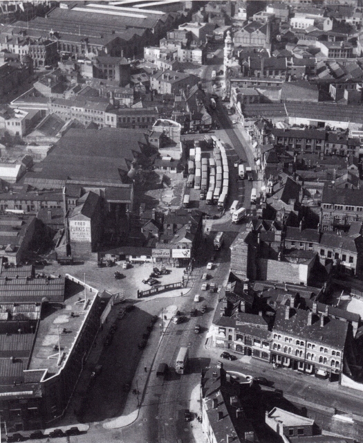
epw005841 ENGLAND (1921). High Street Deritend and environs, Digbeth, 1921

© Copyright OpenStreetMap contributors and licensed by the OpenStreetMap Foundation. 2025. Cartography is licensed as CC BY-SA.
Nearby Images (15)
EPW005841

EPW037038

EPW037036

EPW037037

EPW037035

EPW037039

EPW050088

EPW037040

EPW050089

EPW050087

EPW050371

EPW050370

EPW050372

EPW050091

EPW053097

Details
| Title | [EPW005841] High Street Deritend and environs, Digbeth, 1921 |
| Reference | EPW005841 |
| Date | March-1921 |
| Link | |
| Place name | DIGBETH |
| Parish | |
| District | |
| Country | ENGLAND |
| Easting / Northing | 407814, 286304 |
| Longitude / Latitude | -1.8849464318276, 52.474241668666 |
| National Grid Reference | SP078863 |
Pins
 Michellezellig |
Thursday 23rd of April 2020 03:14:04 PM | |
James Phillips |
Thursday 11th of July 2019 01:58:50 PM | |
kevofbrum |
Wednesday 5th of October 2016 06:02:59 PM | |
kevofbrum |
Wednesday 5th of October 2016 05:55:27 PM | |
kevofbrum |
Wednesday 5th of October 2016 05:49:32 PM | |
kevofbrum |
Wednesday 5th of October 2016 05:48:53 PM | |
kevofbrum |
Wednesday 5th of October 2016 05:47:53 PM | |
kevofbrum |
Wednesday 5th of October 2016 05:38:49 PM | |
kevofbrum |
Wednesday 5th of October 2016 05:31:47 PM | |
PURCELL |
Saturday 22nd of March 2014 09:39:52 PM | |
 offshoredaze |
Sunday 8th of December 2013 11:55:56 AM | |
HenryWRWhite |
Thursday 20th of December 2012 10:05:59 PM | |
HenryWRWhite |
Thursday 20th of December 2012 10:04:40 PM | |
HenryWRWhite |
Thursday 20th of December 2012 10:03:14 PM | |
HenryWRWhite |
Thursday 20th of December 2012 10:01:22 PM | |
Deswill |
Monday 2nd of July 2012 10:15:16 PM | |
 Brasspot |
Monday 2nd of July 2012 09:14:27 PM | |
Brasspot |
Monday 2nd of July 2012 09:12:48 PM | |
Brasspot |
Monday 2nd of July 2012 08:23:00 PM | |
Brasspot |
Monday 2nd of July 2012 08:06:07 PM | |
Brasspot |
Monday 2nd of July 2012 08:02:19 PM | |
Brasspot |
Monday 2nd of July 2012 07:52:43 PM | |
Brasspot |
Monday 2nd of July 2012 07:46:56 PM | |
Brasspot |
Monday 2nd of July 2012 07:42:33 PM | |
Brasspot |
Monday 2nd of July 2012 07:35:31 PM | |
Brasspot |
Monday 2nd of July 2012 07:35:00 PM | |
Brasspot |
Monday 2nd of July 2012 07:11:26 PM | |
Brasspot |
Monday 2nd of July 2012 07:08:39 PM | |
Brasspot |
Monday 2nd of July 2012 06:19:21 PM | |
Brasspot |
Monday 2nd of July 2012 06:14:15 PM | |
Brasspot |
Monday 2nd of July 2012 05:57:57 PM | |
When it was demolished it was already in a state of dereliction, having been bombed during the war. |
Brasspot |
Monday 2nd of July 2012 08:10:44 PM |
Toby Clempson |
Wednesday 27th of June 2012 06:42:02 AM | |
Toby Clempson |
Tuesday 26th of June 2012 07:25:28 PM | |
Paulie |
Tuesday 26th of June 2012 07:14:16 PM | |
Mr Pastry |
Tuesday 26th of June 2012 07:10:06 PM | |
Brasspot |
Tuesday 26th of June 2012 05:09:20 PM | |
Brasspot |
Tuesday 26th of June 2012 05:07:06 PM | |
Brasspot |
Tuesday 26th of June 2012 05:03:14 PM | |
Brasspot |
Tuesday 26th of June 2012 05:02:05 PM | |
Brasspot |
Tuesday 26th of June 2012 05:00:51 PM | |
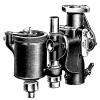
The site was previously that of the Birmingham Battery and Metal Company which was used at the end of the 1800s to produce some of the first cars built in Britain - the Anglo-French. |
Brasspot |
Tuesday 26th of June 2012 05:10:59 PM |
Susannah |
Monday 25th of June 2012 11:52:13 PM | |
One of the handful of surviving 'proper pubs' in the city centre. |
Brasspot |
Monday 2nd of July 2012 07:26:08 PM |
Susannah |
Monday 25th of June 2012 11:43:31 PM |

User Comment Contributions
 Digbeth/Deritend |
Paulie |
Tuesday 4th of September 2012 09:26:57 PM |
 Another view from above. High street Digbeth/deritend 1953. |
Paulie |
Tuesday 4th of September 2012 09:26:57 PM |
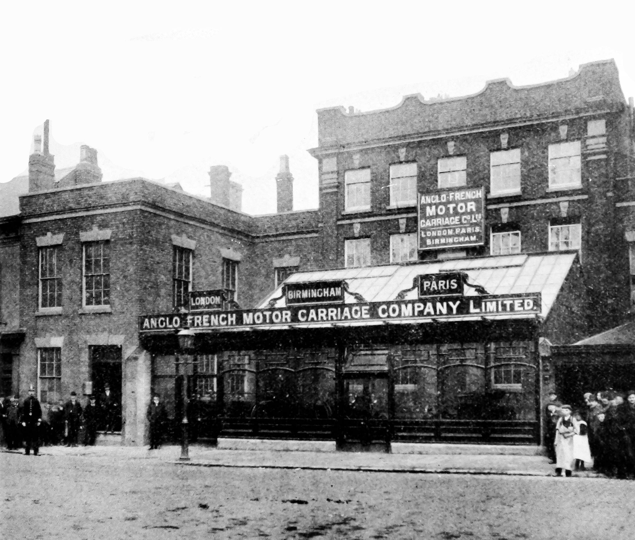 These were the offices and Works of the Anglo-French company who were one of the first car manufacturers in the country. They used to be the premises of the Birmingham Battery and Metal Company and were demolished to make way for the Digbeth Institute in about 1908. |
Brasspot |
Monday 2nd of July 2012 04:56:52 PM |
Dear all, That’s great; we’ve reviewed your comments and thanks to your help we can update the catalogue. The revised record will appear here in due course. Hope you have the same success solving some of our other mysteries! Katy Whitaker Britain from Above Cataloguer |
Katy Whitaker |
Monday 2nd of July 2012 01:55:52 PM |
Picture taken over Moseley St looking NNE. The viaduct carries the GWR Oxford & B'ham railway with Snow Hill Station off to the left. In the foreground running left to right are Rea St, River Rea & Birchall St, crossing Cheapside, Bradford St and Digbeth High St. Floodgate St passes diagonally under the viaduct. Beyond the viaduct at top-left can be seen Curzon St Goods Station and the B'ham & Fazeley Canal in the centre. |
Steve H |
Saturday 30th of June 2012 07:57:02 PM |
This photo encompasses the works of Ashton-Evans, VAL, Rollo, British Peerless, Lanchester, Revolette, Anglo-French, Calthorpe and Hands. |
Brasspot |
Tuesday 26th of June 2012 08:04:00 PM |
Deritend/Digbeth |
Steve Beauchampe |
Tuesday 26th of June 2012 02:38:32 AM |
Digbeth, Birmingham. I examined the rail bridge using Google street view, and it seems to be the same one in the picture |
BigDom |
Monday 25th of June 2012 06:08:58 PM |