
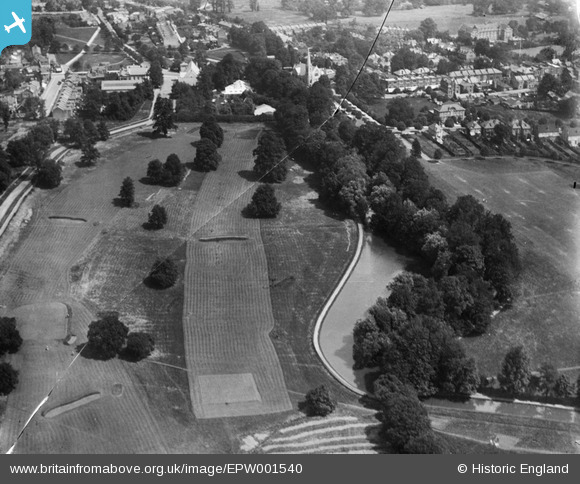
epw001540 ENGLAND (1920). The Golf Course, Enfield Town, 1920
© Copyright OpenStreetMap contributors and licensed by the OpenStreetMap Foundation. 2024. Cartography is licensed as CC BY-SA.
Nearby Images (2)
EPW001540

EPW025293

Details
| Title | [EPW001540] The Golf Course, Enfield Town, 1920 |
| Reference | EPW001540 |
| Date | June-1920 |
| Link | |
| Place name | ENFIELD TOWN |
| Parish | |
| District | |
| Country | ENGLAND |
| Easting / Northing | 532311, 196354 |
| Longitude / Latitude | -0.087304959683134, 51.649923434469 |
| National Grid Reference | TQ323964 |
Pins
 Greg Newsum |
Sunday 19th of January 2020 08:30:55 PM | |
Greg Newsum |
Sunday 19th of January 2020 08:30:01 PM | |
Ray Flack |
Tuesday 29th of July 2014 05:11:33 PM | |
Ray Flack |
Tuesday 29th of July 2014 05:08:01 PM | |
Ray Flack |
Tuesday 29th of July 2014 05:05:23 PM | |
Ray Flack |
Tuesday 29th of July 2014 05:02:36 PM | |
Ray Flack |
Tuesday 29th of July 2014 05:01:46 PM | |
Ray Flack |
Tuesday 29th of July 2014 04:59:42 PM | |
Ray Flack |
Tuesday 29th of July 2014 04:56:07 PM | |
Ray Flack |
Tuesday 29th of July 2014 04:55:11 PM | |
Ray Flack |
Tuesday 29th of July 2014 04:54:18 PM | |
Ray Flack |
Tuesday 29th of July 2014 04:53:28 PM | |
Ray Flack |
Tuesday 29th of July 2014 04:51:55 PM | |
Macmartyn |
Tuesday 25th of June 2013 03:14:26 PM | |
Macmartyn |
Tuesday 25th of June 2013 03:13:40 PM | |
Macmartyn |
Tuesday 25th of June 2013 03:12:24 PM | |
Macmartyn |
Tuesday 25th of June 2013 03:08:10 PM | |
Macmartyn |
Tuesday 25th of June 2013 03:06:46 PM |


