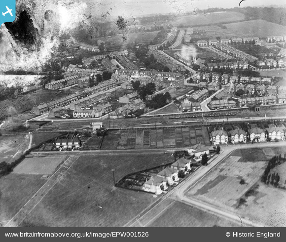
epw001526 ENGLAND (1920). Station Road and environs, Chingford, 1920
© Copyright OpenStreetMap contributors and licensed by the OpenStreetMap Foundation. 2024. Cartography is licensed as CC BY-SA.
Details
| Title | [EPW001526] Station Road and environs, Chingford, 1920 |
| Reference | EPW001526 |
| Date | June-1920 |
| Link | |
| Place name | CHINGFORD |
| Parish | |
| District | |
| Country | ENGLAND |
| Easting / Northing | 538986, 194303 |
| Longitude / Latitude | 0.0083121585293523, 51.629880891742 |
| National Grid Reference | TQ390943 |
Pins
 Sue E M |
Tuesday 21st of September 2021 12:40:05 PM | |
Sue E M |
Tuesday 21st of September 2021 12:37:04 PM | |
Ray Flack |
Friday 17th of October 2014 12:21:51 PM | |
Ray Flack |
Sunday 10th of November 2013 03:15:28 PM | |
Ray Flack |
Sunday 10th of November 2013 03:14:25 PM | |
Ray Flack |
Sunday 10th of November 2013 03:13:49 PM | |
Ray Flack |
Sunday 10th of November 2013 03:12:34 PM | |
Ray Flack |
Sunday 10th of November 2013 03:09:25 PM | |
Ray Flack |
Sunday 10th of November 2013 03:07:14 PM | |
Ray Flack |
Sunday 10th of November 2013 03:06:37 PM | |
Ray Flack |
Sunday 10th of November 2013 03:05:53 PM | |
Ray Flack |
Sunday 10th of November 2013 03:05:16 PM | |
Ray Flack |
Sunday 10th of November 2013 03:02:49 PM |